
Gimhae Astronomical Observatory (김해천문대)
14.0Km 2022-12-29
254, Gaya thema-gil, Gimhae-si, Gyeongsangnam-do
+82-55-337-3785
Gimhae Astronomical Observatory opened on February 1, 2002 as part of the Millennium Commemorative Project that started in December 1998. It was built to satisfy the general public’s curiosity about the universe and celestial bodies, inspire young people, and give everyone a unique, memorable experience. The observatory is shaped like an egg, in memory of the legend of King Kim Suro, the founder of the Garak Kingdom, according to which the king was born from an egg.
It is said that the queen of King Suro, Heo Hwang-ok, was a princess from the Indian country of Ayuta. Since sophisticated navigation equipment had yet to be invented, it can be assumed that she found her way to the Garak Kingdom by following the stars. It is also said that a prince of the Garak Kingdom built an observatory on the highest point of a mud fortress in Jinrye in order to make astronomical observations. The place is still referred to as Bibidan, which means a place to watch the stars.
These historical facts indicate the stars were very important to the Gaya, an ancient kingdom established mainly in the Gimhae area. The peak of Bunseongsan Mountain, where the observatory is located, offers sweeping views of the entire area of Gimhae. The night sky of Gimhae offers a breathtaking sight.
![Uniqlo - Lotte Dongnae Branch [Tax Refund Shop] (유니클로 롯데동래)](http://tong.visitkorea.or.kr/cms/resource/84/2885484_image2_1.jpg)
Uniqlo - Lotte Dongnae Branch [Tax Refund Shop] (유니클로 롯데동래)
14.1Km 2024-04-23
1393, Jungang-daero, Dongnae-gu, Busan
-
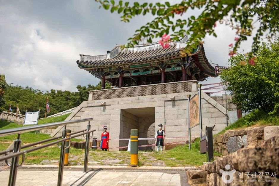
Bunsanseong Fortress (김해 분산성)
14.2Km 2023-01-18
210-162, Gaya-ro 405beon-gil, Gimhae-si, Gyeongsangnam-do
+82-55-330-3925
Bunsanseong Fortress was constructed in the 3rd year of the reign of Goryeo's King U (1377) by Magistrate Park Wi to defend against foreign enemies, but it was destroyed during the Japanese invasion of 1592. The fortress we see today was reconstructed by Magistrate Jeong Hyeon-seok in the 8th year of the reign of Joseon's King Gojong (1871). However, it is estimated that it was first built during the days of Gaya. It is a temoe-style fortress with rocks piled up like a long band at the peak of Bunsan from which downtown Gimhae, Gimhae Plains, the Nakdonggang River and the South Sea are all in a single, panoramic view. Today, fortress walls remain stretching for some 900 meters on the slope towards the city and, inside the fortress, there are two gate sites in the south and north, an auxiliary gate on the west, a well site and several other building sites. The exact length of the remaining fortress walls is 929 meters and the average x_width is about 8 meters.
Inside the fortress lies Haeeunsa Temple, which was built to pay respects to Queen Heo of Garak who had come from the sea, according to stories. The temple also enshrines portraits of King Suro and Queen Heo that were painted during the Joseon dynasty. During the Japanese invasion of 1592, monk soldiers were stationed at this temple.
The fortress is more popularly called "Manjangdae" by Gimhae locals, and this name originated from the description, "A tall tower 10,000 (man) gil in x_height," granted by Daewongun in the Joseon dynasty for this advanced base that defeats Japanese invaders. A writing of "Manjangdae" written by Daewongun himself as well as his stamp are engraved on a rock behind a beacon that was restored in 1999.
Gimhae Gujibong Peak (김해 구지봉)
14.3Km 2021-07-13
Gusan-dong, Gimhae-si, Gyeongsangnam-do
+82-055-331-0086
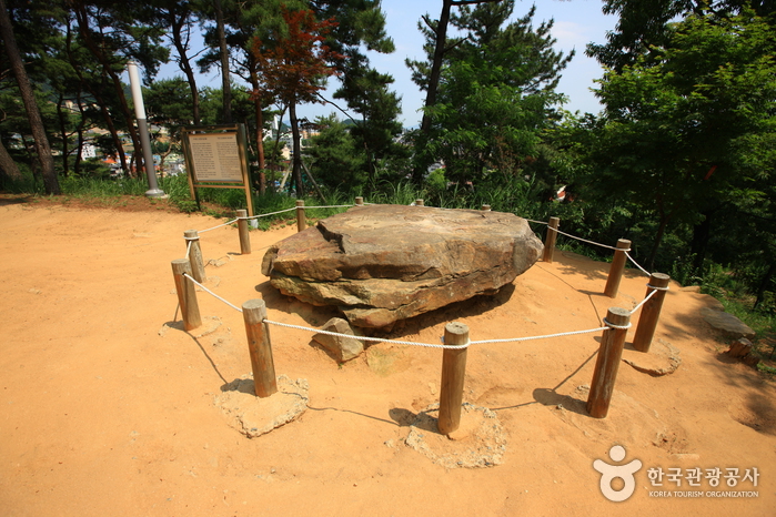
Gujibong Peak in Gusan-dong, Gimhae in Gyeongsangnam-do is believed to be the birthplace of King Suro, the founder of the Gaya kingdom. The peak was originally named Gusubong (“gu” meaning “turtle,” “su” meaning “head”) after its resemblance to the head of a turtle. The flat part of the peak (the turtle’s “head”) is home to the Tomb of King Suro. On the summit is a southern-style dolmen dating back to the 4th century BC that consists of 5 or 6 support stones and a large cover stone measuring 2.5m in diameter. The cover stone bears the inscription “Gujibongseok,” said to be written by Han Ho.
Gujibong Peak is considered a sacred place by the local people because, according to legend, it is the place where the creation of the Gaya Kingdom took place. During the Japanese colonial rule, the “neck” of the turtle was destroyed by the construction of a mountain road. Years later, a pedestrian road was built to rejoin the neck and restore the feng shui of the mountain.
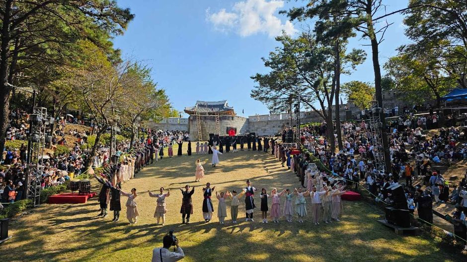
Dongnaeeupseong History Festival (동래읍성역사축제)
14.5Km 2025-07-11
80 Munhwa-ro, Dongnae-gu, Busan
+82-51-550-4092
The Dongnaeeupseong History Festival offers an immersive experience of the history and culture of Dongnaeeupseong Walled Town, where the Battle of Dongnaeseong Fortress took place against the Japanese army during the Imjin War in 1592. Highlights include a musical dramatizing the patriotic spirit of the Dongnae Governor during the battle and various hands-on experiences, such as participating as Dongnae citizens using traditional Joseon-era coins.
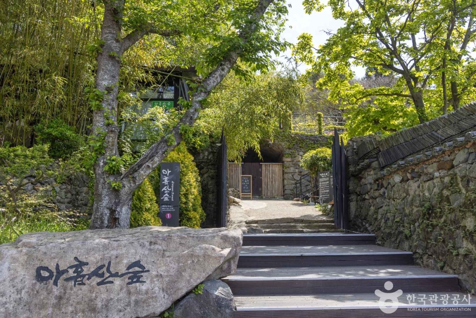
Ahopsan Forest (아홉산숲)
14.6Km 2025-10-23
37-1 Midong-gil, Gijang-gun, Busan
Ahopsan Forest is a forest located at the foot of Ahopsan Mountain in Cheolma-myeon, Gijang-gun, Busan. It is a place where visitors can meet the undamaged natural environment and ecology. Diverse forests ㅡsuch as bamboo forests, cypress forests, cedar trees, ginkgo trees, and natural forests, including Geumgang pine trees aged 100 to 300 years, make up Ahopsan Mountain. It is a private forest with a total area of 520,000 square meters and has been there for about 400 years. Only a limited number of people who have made a reservation in advance are allowed to enter for nature conservation. Unlike amusement parks and recreation areas, viewing is possible only within the limits that do not damage nature. However, forest experiences, activity programs for children, and forest explanation program are offered for visitors' entertainment.
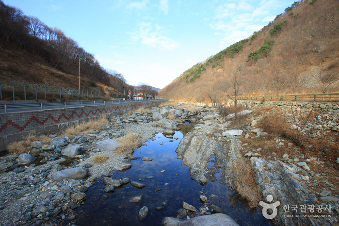
Baenaegol Valley (배내골)
14.9Km 2021-04-03
Wondong-myeon, Yangsan-si, Gyeongsangnam-do
+82-55-382-4112
Baenaegol Valley is located at the heart of the mountainous region affectionately known as the Yeongnam Alps. The valley derives its name “Baenaegol,” meaning “the valley of pears,” from the wild pear trees that grow in large numbers along the valley.
The valley covers nearly 8 kilometers of land between the range connecting Sinbulsan Mountain and Yeongchuksan Mountain and the western range connecting Cheonhwangsan Mountain and Jaeyaksan Mountain in Miryang. It is a popular vacation destination in the summer. Also, many tourists come to drink the water containing acer mono sap, which is known to be produced in this region during the springtime.
Baenaegol Valley is just a short distance away from downtown Yangsan. The valley provides an opportunity to enjoy nature away from the hustle and bustle of the city center. The long valley is wedged between highlands, which results in at least two hours less of sunshine than other regions, so it feels cooler in the summer months. Strawberries are also widely grown in the area.
Site of Dongnaeeupseong Walled Town (동래읍성지)
15.4Km 2024-09-26
48-2 Myeongnyun-dong, Dongnae-gu, Busan
Site of Dongnaeeupseong Walled Town, built towards the end of the Goryeo dynasty and the early Joseon dynasty, was a significant fortress during the Imjin War in 1592. It served as the main battleground where civilians, officials, and soldiers united to resist the Japanese forces. Recognizing the strategic importance of the Dongnae area, a much larger fortress was constructed in 1731, replacing the original structure from one built during war. Today, only traces of the fortress remain, with the Bukmun Gate, Insaengmun Gate, Dongjangdae Command Post, Seojangdae Command Post, and Bukjangdae Command Post having been restored.
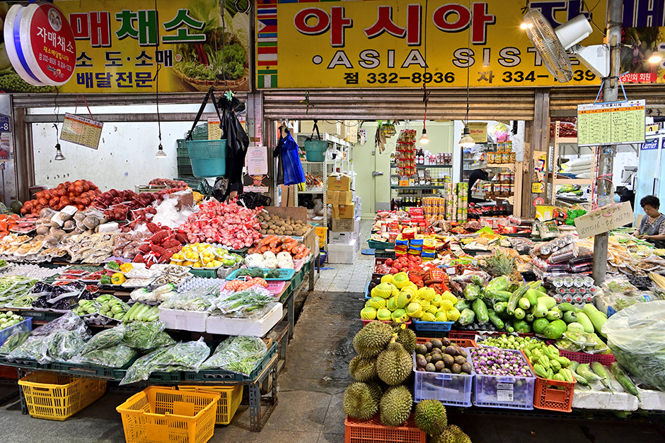
Dongsang Market (동상시장)
15.6Km 2025-10-23
25 Guji-ro 180beon-gil, Gimhae-si, Gyeongsangnam-do
Formed in 1945, Dongsang Market is a lifestyle-centric traditional market that offers a slew of daily necessities like vegetables, fruits, rice cakes, fishery products, and side dishes, as well as a popular alley specializing in Kalguksu (noodle soup). Designated as a cultural tourism market in 2017, it has since evolved into a vibrant space where traditional Korean culture harmoniously coexists with diverse global cultures. As more foreign workers have begun frequenting the market in recent years, a number of Asian grocery stalls have opened. In particular, vegetables favored by Southeast Asian customers, ritual foods, and Kalguksu (noodle soup) have become local specialties.
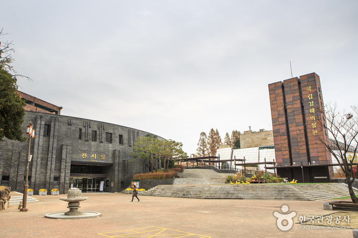
Gimhae National Museum (국립김해박물관)
15.7Km 2024-01-23
190 Gayaui-gil, Gimhae-si, Gyeongsangnam-do
The Gimhae National Museum was opened on July 29, 1998, in order to research and preserve the cultural heritage of the ancient kingdom of Gaya. The museum is at the foot of Gujibong Peak in Gimhae-si, the spot where the kingdom is believed to have been founded. The museum exhibits the cultural assets of Gaya, as well as cultural relics from the prehistoric age in the Busan and Gyeongsangnam-do areas, and the cultural heritage of Byeonhan, which was the foundation for the growth of Gaya.
The exterior of the museum is made using black bricks representing iron ore and charcoal famous during the Gaya Kingdom. There are two exhibition halls, while the walkway to the halls have approximately 1,300 artifacts in display.
 English
 한국어
한국어 日本語
日本語 中文(简体)
 Deutsch
 Français
 Español
 Русский