Hantangang River Jusangjeolli-gil (철원 한탄강 주상절리길(잔도))
11.8Km 2024-11-04
San78-2 Guntan-ri, Galmal-eup, Cheorwon-gun, Gangwon-do
This 3.6-km trail in the Hantangang River UNESCO Global Geopark is filled with awe-inspiring cliffs and various size rocks. Walking alongside the cliff, the world unfolds thrillingly beneath your feet. It takes about 1 hour and 30 minutes one way, and on weekends, shuttle buses run between the two entrances, so there's no need to return to the starting point. As you traverse this exhilarating path, you might imagine the "Hangout with Yoo" team walking with their flags as if participating in a team-building exercise.
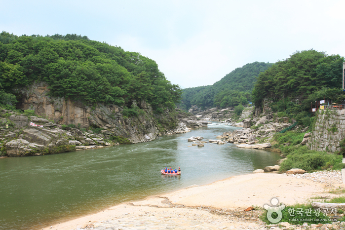
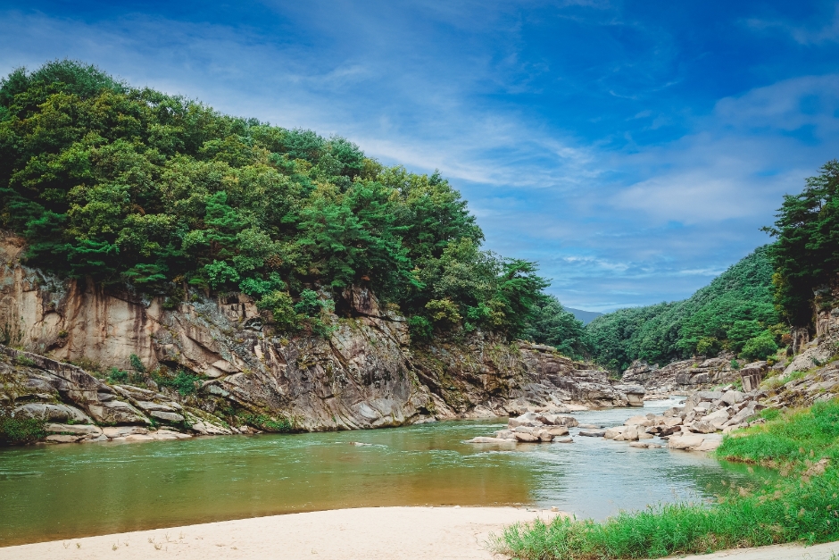
Sundamgyegok Valley (순담계곡)
11.9Km 2025-01-07
143-3, Sundam-gil, Cheorwon-gun, Gangwon-do
+82-33-450-5365
Located 5 kilometers northwest of Cheorwon-gun Office, Sundamgyegok Valley is one of the most beautiful valleys among the branches of the Hantangang River. It offers fantastic scenery of fascinating rock formations, steep cliffs, and ponds. The valley is filled with abundant water, trimmed by rare naturally white sand. Also, the stream behind the valley attracts many rafters each year.
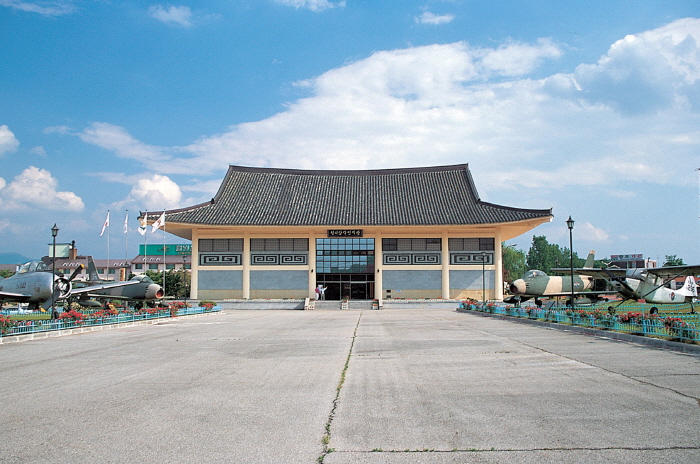
Cheorwon Facilities Management Office (Formerly, Iron Triangle Battlefield (철원 시설물관리사업소 (구 철의삼각전적관))
13.1Km 2025-03-15
1825, Taebong-ro, Cheorwon-gun, Gangwon-do
+82-33-450-5559
Located in Goseokjeong National Tourism Site, Cheorwon Facilities Management Office is the main tourism center hosting the Cheorwon tour. Starting from Security Tourist Site Development Plan by Cheorwon-gun county in 1976 , the Ministry of Transportation designated Goseokjeong as Goseokjeong National Tourist Area in 1977. The military and Cheorwon-gun county carried out security and battlefield excavation and preservation projects, and established a security educational site featuring the national largest scale in 1985.
Presently, the Iron Triangle Battlefield, located in Goseokjeong National Tourist Area, is used as a security educational site. Unification Hall found within houses various exhibitions, giving information to compare with current and past lifestyles and military devices including varied aircrafts displayed in the outdoor exhibition area. In the educational hall, a promotional video for Cheorwon is screened. Likewise, the exhibition hall covers various materials that allow one to think about unification between North Korea and South Korea.
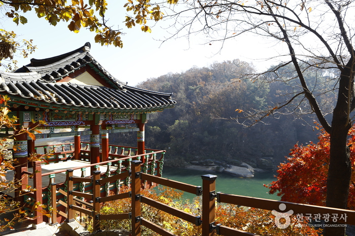
Goseokjeong National Tourist Area (고석정국민관광지)
13.1Km 2023-03-07
1825, Taebong-ro, Cheorwon-gun, Gangwon-do
+82-33-450-5558
Goseokjeong Pavilion is the most scenic spot among the eight scenic views of Cheorwon. The crystal clear waters of the Hantangang River wind around Goseokbawi Rock, a peculiarly shaped rock about 10 meters tall that stands dominantly in the middle of the river. Goseokjeong Pavilion is a two-story tower-style pavilion that has an area of about 33 square meters, built halfway up the Hantangang River during the reign of King Jinpyeong (r. AD 579-632) of the Silla Kingdom. Today, Goseokjeong refers to the entire area around Goseokjeong Pavilion and the valley surrounding Goseok Rock. Designated as a Monument of Gangwon-do, the pavilion is known to have been one of the most favored places by King Jinpyeong of the Silla Kingdom, and King Chungsuk of the Goryeo dynasty. The area became all the more famous as the arena of Im Kkeok-jeong (?-1562), who was a legendary leader of a peasant rebellion in the early Joseon dynasty.
The pavilion was destroyed during the Korean War and restored in 1971 by community leaders in Cheorwon. Unfortunately, it was damaged once again by flood in 1996 and reconstructed the year after. There is a natural stone chamber inside Goseokbawi Rock that Im Kkeok-jeong used as a hiding place. On the opposite side, there are remains of a stone castle. Jiktang Waterfall is located about 2 kilometers up from this site, while Sundam Valley is situated about 2 kilometers in downstream. Goseokjeong is a year-round tourist attraction with an extensive grass square and recreational facilities. It is also the starting point for DMZ tours as the Iron Triangle Battlefield Conservation Office is located here and in winter, visitors can enjoy migratory bird tours.
![Hantangang River [National Geopark] (한탄강(국가지질공원, 고석정))](http://tong.visitkorea.or.kr/cms/resource/52/2675252_image2_1.jpg)
Hantangang River [National Geopark] (한탄강(국가지질공원, 고석정))
13.3Km 2022-06-02
1825 , Taebong-ro, Cheorwon-gun, Gangwon-do
+82-33-450-4810
Goseok Rock, located in the area of Hantangang River, is a granite rock that reach 15 meters in x_height. The area is often called Goseokjeong, named after the nearby Goseokjeong Pavilion. The area is an important geology and topography learning site where it is visible to see the topography before the formation of the basalt lava field and the fact that the basalt lava flowed over the bedrock to form the lava field. Goseok is a bedrock that existed before the area of Cheorwon was covered with lava, and is a granite formed underground about 110 million years ago (mid Cretaceous period). It is covered in basalt lava by volcanic activity that occurred between about 540,000 and 120,000 years ago, and then eroded by the Hantangang River to form a new waterway.
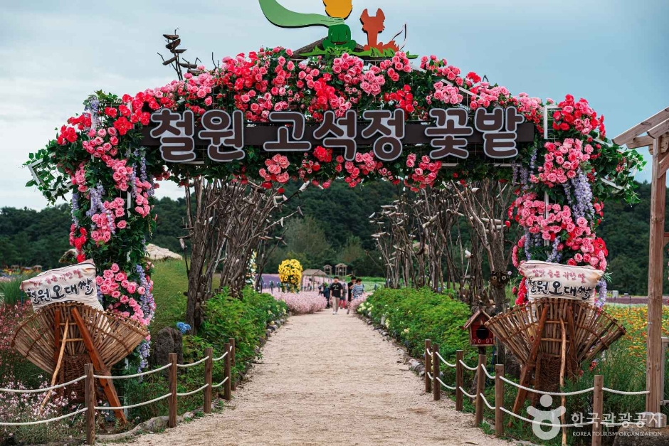
Goseokjeong Flower Field (고석정 꽃밭)
13.3Km 2024-11-04
10-2 Jangheung-ri, Dongsong-eup, Cheorwon-gun, Gangwon-do
It is a vibrant flower field where you can encounter various flowers depending on the season. Amidst the endless bloom, take photos and create memories like the members of "Hangout with Yoo" or joyfully play around, shouting "Catch me if you can!" like the members from "Running Man."
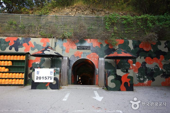
The 2nd Tunnel (제2땅굴(철원))
13.3Km 2024-03-20
Yangji-ri, Dongsong-eup, Cheorwon-gun, Gangwon-do
+82-33-450-5559
The 2nd Tunnel, one of several excavated by North Korea for the purpose of infiltrating South Korea, was discovered in 1975. Spanning a total length of 3.5 kilometers, only 500 meters of the tunnel is accessible to civilians. To visit this site, visitors are required to book as part of the DMZ Peace Tours. Additionally, personal identification, such as a passport or Alien Registration Card (ARC), is necessary for access.
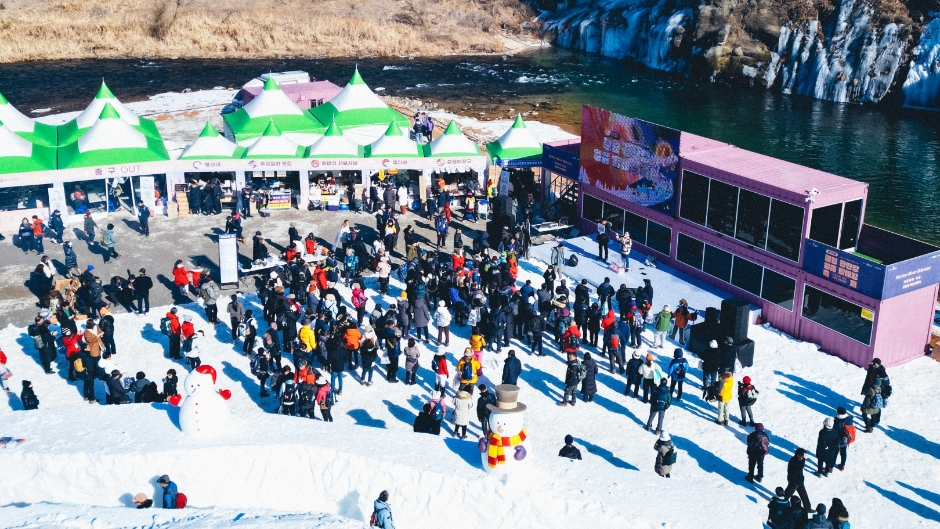
Cheorwon Hantangang River Ice Trekking Festival (철원 한탄강 얼음트레킹 축제)
13.4Km 2025-01-08
25-203 Jangheung-ri, Dongsong-eup, Cheorwon-gun, Gangwon-do
+82-33-455-7072
The Cheorwon Hantangang River Ice Trekking Festival is an eco-tourism festival held along the frozen Hantangang River in Cheorwon, Gangwon-do. The festival’s main attraction is walking on the ice of the Hantangang River while viewing the stunning rock formations and columnar joints of the gorge of the Hantangang River and Jiktangpokpo Falls, the "Niagra of Korea."Other popular activities include a snow sledding area, giant snow sculptures, a winter playground, and a winter food market.
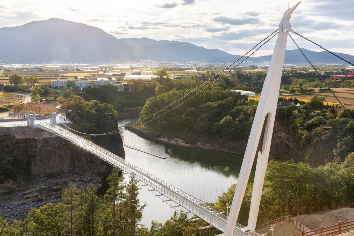
Cheorwon Hantangang Milky Way Bridge (철원 한탄강 은하수교)
14.8Km 2023-03-07
725-12, Jangheung-ri, Cheorwon-gun, Gangwon-do
+82-33-450-5365
The area of Hantangang River is a UNESCO Global Geopark. The Milky Way Bridge was built to follow a natural path and allows visitors to journey comfortably. The name of the bridge takes from the famous Hantangang River and region of Cheorwon and adds eunhasu, or Milky Way, the path made of stars.
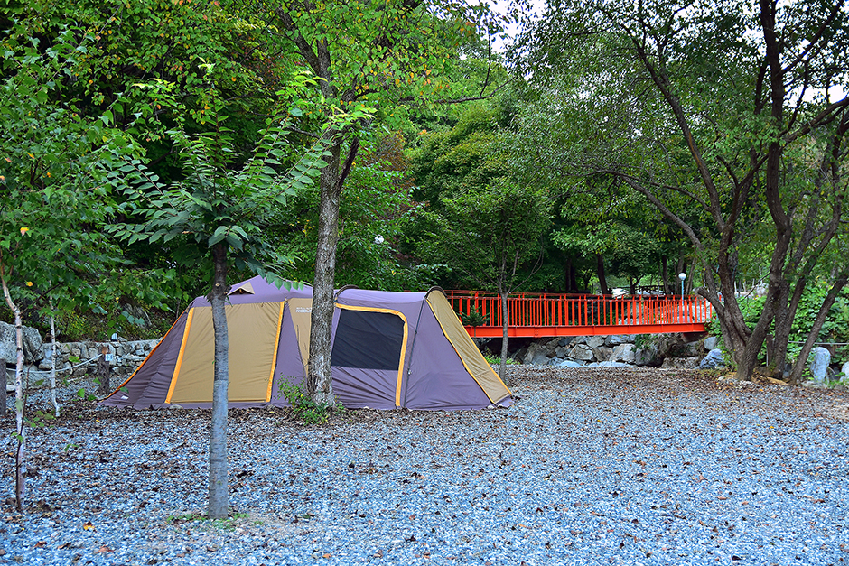
Damteo Oji Camping Ground (담터오지캠핑장)
15.0Km 2024-11-04
409 Damteo-gil, Gwanin-myeon, Pocheon-si, Gyeonggi-do
Where did “Team Hwasa” visit for fresh and clean valley water in Episode 458 of I Live Alone? The spot is none other than Damteo Oji Camping Ground. This healing place lets you experience natural comfort and an emotional atmosphere. How about spending a night camping here listening to the sound of valley water flowing?
 English
 한국어
한국어 日本語
日本語 中文(简体)
 Deutsch
 Français
 Español
 Русский