Sinsido Island Fishing Experience Village (신시도 어촌체험마을)
.0M 2025-01-10
83-7, Sinsido-gil, Gunsan-si, Jeonbuk-do
+82-63-463-7088
Sinsido Island is the largest of the 24 islands in the Gogunsan Island Cluster located 50 kilometers southwest of Gunsan. The highest point is Daegaksan Mountain (187 meters) on the northwest side and there is Sinchisan Mountain (142 meters) on the southeast side. Villagers tend to work in the fishing industry, catching shrimp, anchovies, hairtail, and mackerel. Farmers tend to grow rice, barley, sweet potato, chili, peas and more. The island can be reached by car and there are various activities available such as mud flats and fishing.

Munyeodo Island & Seonyudo Island (무녀도‧선유도)
4.7Km 2024-04-07
Okdo-myeon, Gunsan-si, Jeonbuk-do
+82-63-454-7280
Munyeodo Island is located approximately 50.8 kilometers southwest of Gunsan-si, and forms the Gogunsan Islands together with Seonyudo, Sinsido, Jangjado, and other islands. Its total area occupies 1.75 square kilometers and its coastline is 11.6 kilometers long. Today, with Seonyudo in the middle, there are bridges installed between Munyeodo and Seonyudo, Seonyudo and Jangjado, and Jangjado and Daejangdo, so visitors are able to walk around as if they are on a single island. Other than Munyeobong Peak (131 meters) on the southwestern part of the island, the region is vast but lacks any tall mountains.
Seonyudo Island is located in the center of the Gogunsan Islands, which consist of about 20 islands, and is approximately 50 kilometers away from Gunsan Port. It is also one of the most popular vacation spots on the entire West Coast.
The location that serves as a basecamp when travelling to Seonyudo and the nearby islands is Jin-ri Village on Seonyudo. It neighbors Seonyudo Beach, which is famously known as ""Myeongsasimni,"" and faces Mangjubong Peak that stands tall like Maisan mountain. The island is crowded with schools, inns, restaurants, bike rental shops, stores, karaokes and campgrounds, which is why the area is a bit boisterous during the vacation seasons. If you wish to escape from such noise, it would be a good idea to rent a bicycle and bike to Munyeodo, Jangjado or Jinwol-ri over Mangjubong Peak.
Seonyudo Island is the home of the 8 Scenic Spots of Seonyu, but the most gorgeous scenery of them all is Mangjubong Peak, which is practically the symbol of the island. Once you climb up to the top, the nearby islands and the sea come together in a cool panoramic view, which also includes the neatly sprawling Myeongsasimni Beach as well as Pyeongsanagan that resembles a seagull landing over the water. The splendid sunset on Seonyudo Island is incredible no matter where you are, whether it'll be atop Mangjubong Peak or Seonyudo Beach.
Seonyudo Island (선유도)
5.1Km 2024-04-07
34-22, Seonyunam-gil, Gunsan-si, Jeonbuk-do
+82-63-454-7280
Seonyudo Island, one of the most popular tourist destinations on the west coast during the summer, lies in the heart of the Gogunsan Archipelago. The island has an area of 2.12 ㎢, which is only about 1/4 of Yeouido in Seoul. The island's coastal shore is around 12.8 kilometers long and the highest point is Namaksan Mountain, which reaches about 155.6 meters in altitude. Seonyudo is the central point of Gogunsan Archipelago and has even served as the headquarters for the naval army during the Joseon dynasty. It played a vital role during the Imjin War as Admiral Yi spent days on the islands to prepare for the next battle after his victory in the Battle of Myeongnyang.
Visitors can enjoy the island in three ways. First is to look around the neighboring islands. Seonyudo, Munyeodo, Jangjado, and Daejangdo islands are all connected by a bridge, allowing one to move between the islands on foot or a bicycle. Other ways to enjoy the island is to take a walk along the Myeongsa-simni Shore, one of the Eight Scenes of Seonyudo, and to try the clam collecting program at a mudflat.
Seonyudo Beach (Myeongsasimni Beach) (선유도해수욕장 (명사십리 해수욕장))
5.1Km 2024-04-07
Okdo-myeon, Gunsan-si, Jeonbuk-do
+82-63-454-7280
Seonyudo Beach, is a natural coastal sand dune beach with a vast white sand area as transparent and beautiful as glass beads, which is why it is also known as Myeongsasimni Beach. At Seonyudo Beach, the depth of the water is only waist-high even if you go some 100 meters into the sea, and there are no high waves so you can play in the water safely.
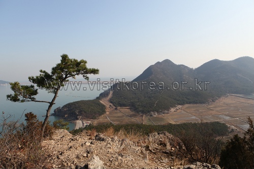
Jangjado Island (장자도)
6.3Km 2024-04-07
26-2 , Jangjado 1-gil, Gunsan-si, Jeonbuk-do
+82-63-454-7280
Jangjado Island is one of the Gogunsan Islands, and it is called Jangjado because the legend has it that a strong man was born here. Locals say that, when a fishing boat runs into a storm in the sea, it is safe to take shelter on this island, which is why it is also known as a refuge harbor. Jangjado Island is connected to Seonyudo Island by Jangjagyo Bridge.
Jangjado Island is located in the very center of all Gogunsan Islands and once you climb up to Daejangbong Peak, the 63 Gogunsan Islands unfold before your eyes like a panorama, making it a popular filming spot chosen by the three broadcasting companies as well as the Corean Alpine Club and the Photo Artists Society of Korea. It offers various leisure activities from a mud flat experience and sea fishing to hiking Daejangbong Peak, which is a famous sunrise and sunset watching spot, and cruise tour of the Gogunsan Islands. There are an abundance of delicious dishes including sliced raw fish, spicy braised seafood, noodle soup with clams and stone crabs, and is home to many other tourist attractions such as Jangjadaegyo Bridge with spectacular sunset view, Jangjahalmeonibawi Rock and Daejangdo Dangje, a type of ritual, which is why it is great to visit anytime of the year.
Myeongdo Island (명도)
11.1Km 2026-01-02
5 Myeongdo-gil, Okdo-myeon, Gunsan-si, Jeonbuk-do
Myeongdo takes its name from the character “myeong,” which means “bright,” as its clear waters were likened to the union of the moon and the sun. It is also known as Yakdo Island, or “Medicinal Island,” for the wide variety of medicinal herbs that thrive there despite constant exposure to sea winds. Centered around Bangchukdo Island, visitors can enjoy sightseeing cruises and fishing by boat, and admire the island’s beautiful and unusual rock formations. In the mountainous areas of the island, dozens of medicinal herb species grow after enduring the harsh sea winds. The most well-known among them is laserwot, called bangpung in Korean, which is traditionally believed to help prevent postpartum pain syndrome in pregnant women and to offer effects such as inducing perspiration, reducing fever, relieving pain, and alleviating neuralgia, purportedly expelling 36 types of pain. It is also said to be effective in improving concentration, particularly for students preparing for exams.
Bieung Port (비응항)
14.2Km 2024-04-07
74-11 , Bieungnam-ro, Gunsan-si, Jeonbuk-do
+82-63-454-4000
Bieung Port is the starting point of Saemangeum Embankment which is at the entrance of the Saemangeum tourist area. Bieung Port was once closed due to the excess of soil sedimentation after the construction of Geumgang Estuary seawall. In addition, when the shores were closed off with the Saemangeum Embankment reconstruction project, a new port was in need and thus Bieung Port was repaired and reopened along with two other ports. Bieung Port in particular was constructed as a multi-functioning fisheries port so that it may be incorporated with the nearby attractions in the tourism business.
Bieung Mapaji Trail (비응 마파지길)
15.1Km 2024-04-06
1331 Oehang-ro, Gunsan-si, Jeonbuk-do
Bieung Mapaji Trail is a deck walkway along the coast of Biungdo Island. "Mapaji" means a place where the maparam (south wind) blows in Korean, and visitors can enjoy a refreshing walk while feeling the cool breeze from the sea. While strolling along the coastal scenery, visitors come across observation decks. From these decks, they can enjoy panoramic views of Bieung Port and the expansive scenery of the Seohae Sea.

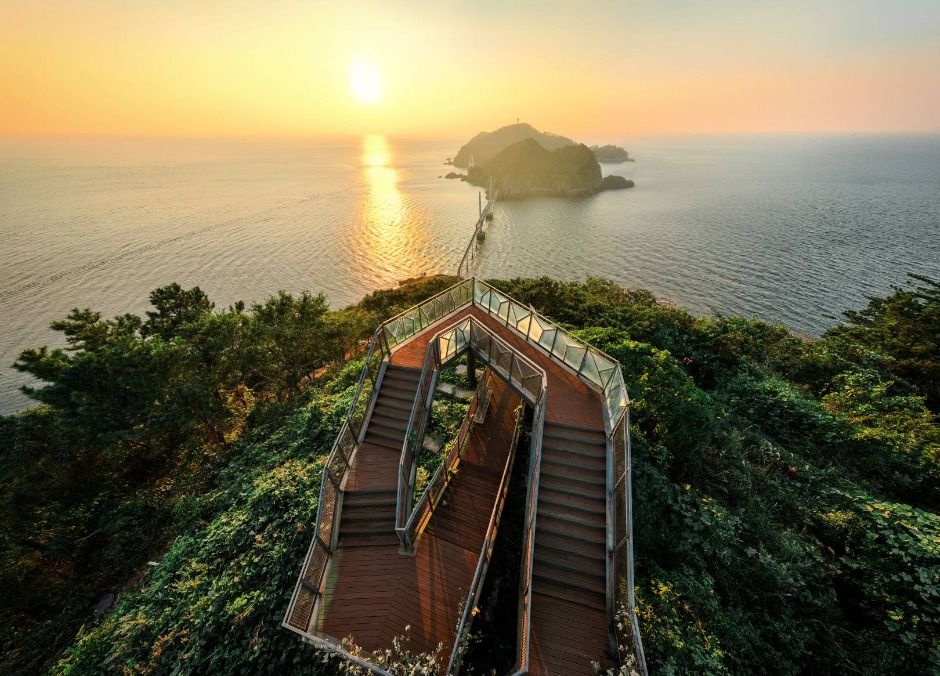
Saemangeum Promotion Hall (새만금홍보관)
16.0Km 2025-11-05
6 Saemangeum-ro, Byeonsan-myeon, Buan-gun, Jeonbuk-do
Enjoy the panoramic view of Saemangeum
This is a PR center to commemorate the Saemangeum Project, which took 19 years to complete. It is a place that encompasses the past, present, and vision of Saemangeum. The inside is much larger and larger than it looks from the outside, and there are so many things to see. When you go up to the observatory on the 3rd floor, the magnificent panoramic view of Saemangeum spreads out in front of you, and you can observe distances beyond your reach with a telescope. Outside the Promotion Hall, there is a monument where BTS' music video is played. There is an endless stream of visitors sitting here and taking commemorative photos.
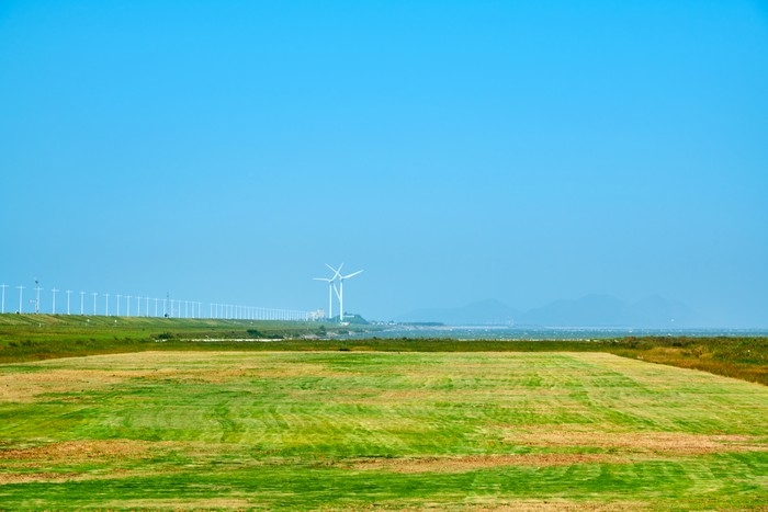
Saemangeum (새만금)
16.0Km 2025-10-23
6 Saemangeum-ro, Byeonsan-myeon, Buan-gun, Jeonbuk-do
+82-63-584-6822
Saemangeum is an area created by the reclamation project to build a sea wall connecting Gunsan and Buan. After 20 years of construction, the Saemangeum Seawall was completed in 2010. Stunning sunsets can be seen from the dike, and various facilities such as campgrounds and the Saemangeum Project Office are well prepared for visitors experience. It is also known as a filming location for BTS's music videos.
 English
 한국어
한국어 日本語
日本語 中文(简体)
 Deutsch
 Français
 Español
 Русский