Noeully (노을리)
11.3Km 0 2024-01-31
656 Aewolhaean-ro, Jeju-si, Jeju-do
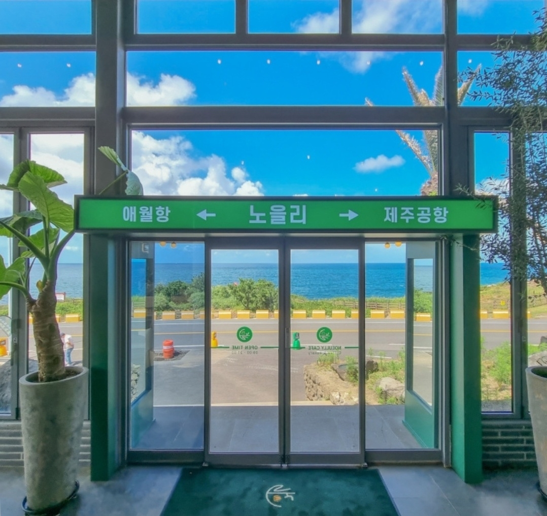
Noeully is a dessert café located in Gueom-ri, Aewol-eup, Jeju-si. The entrance and interior are decorated like a bus stop and a glass greenhouse, respectively, allowing visitors to enjoy tropical plants and the ocean view. It consists of a rooftop café on the second floor and a sky garden on the third floor, as a no-kids zone except on the first floor. Chairs and tables face the sea for an open view of the Jeju sea and sunset, making this café a popular spot to visit for taking photos to post on social media. One of the charms of Noeully is that visitors can enjoy flowers here all year round, such as mustard flowers, hydrangeas, sunflowers, cosmos, and buckwheat flowers. The representative menu item is Briquette bread, a briquette-shaped glutinous rice bread filled with strawberry jam. In addition, the menu includes a variety of drinks, coffee, scones, and cookies.
Timestamp (타임스탬프)
11.8Km 0 2024-03-20
1F, 92-1 Sinbuk-ro, Jocheon-eup, Jeju-si, Jeju-do
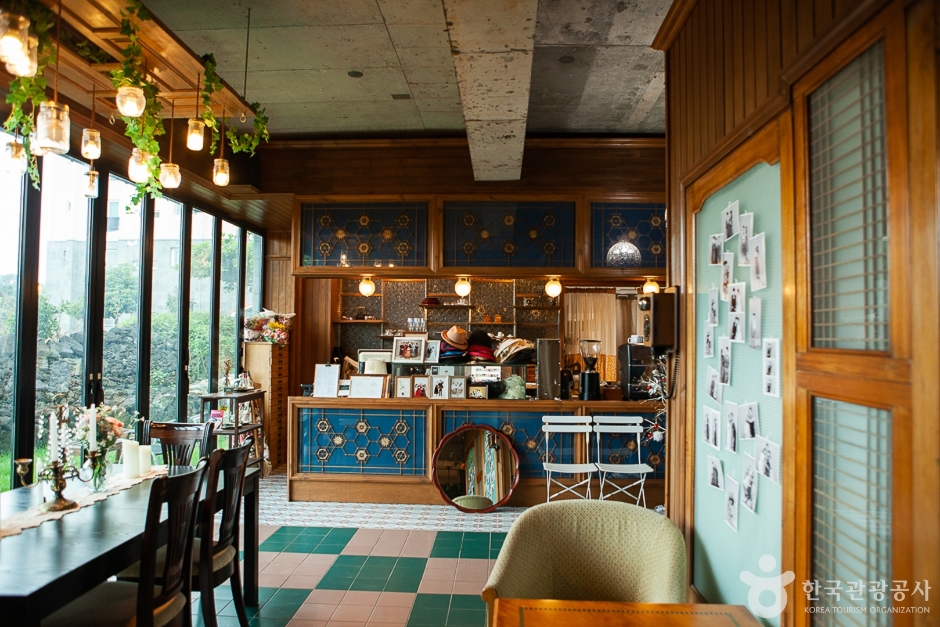
Timestamp is a distinctive café in Jeju that doubles as a small photo studio. Its hallmark offering is the hallabong ade, alongside a selection of other beverages and desserts like Americano and vanilla latte. In its photo studio, visitors have the opportunity to take ID and souvenir photos, with the added feature of a facility for self-service black and white photography. The café's retro-style interior has made it a hit on social media, attracting many visitors.
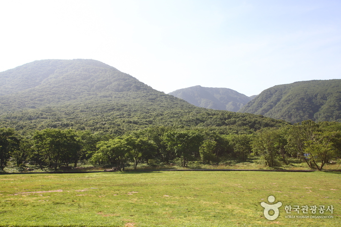
Halla Ecological Forest (한라생태숲)
12.2Km 23796 2021-06-11
2596, 516-ro, Jeju-si, Jeju-do
+82-64-710-8688
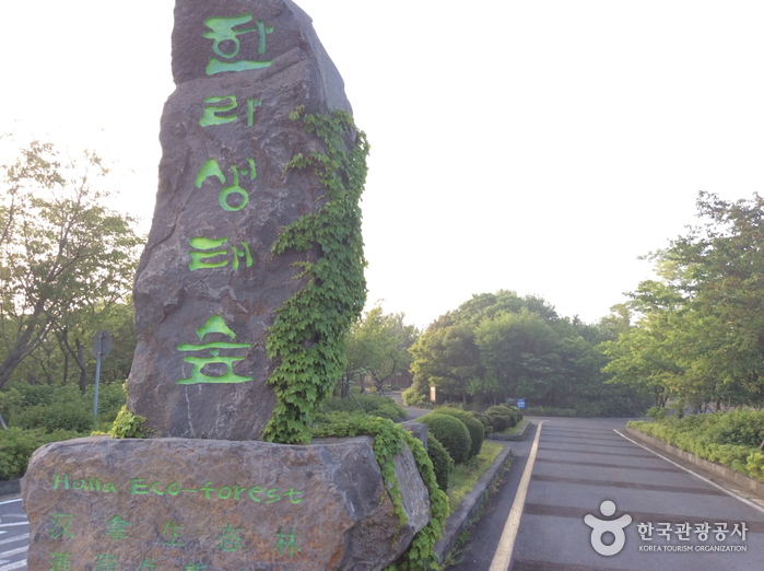
Spanning 196 hectares, Halla Ecological (Eco) Forest is home to 288,000 trees representing 333 indigenous plant species. Having been designated as a conservation area, the forest provides plenty of great opportunities to observe and learn about Jeju's diversified ecosystem through various facilities including an observatory, plant nurseries, walking trails, and more. The forest also features 13 themed forests with low-impact facilities to preserve the essence of the forest. Visitors can sign up for the forest experience program to enjoy the walking trails within the forest.
Jeju 4.3 Peace Park (제주4·3평화공원)
12.5Km 15687 2021-06-18
430, Myeongnim-ro, Jeju-si, Jeju-do
+82-64-723-4344
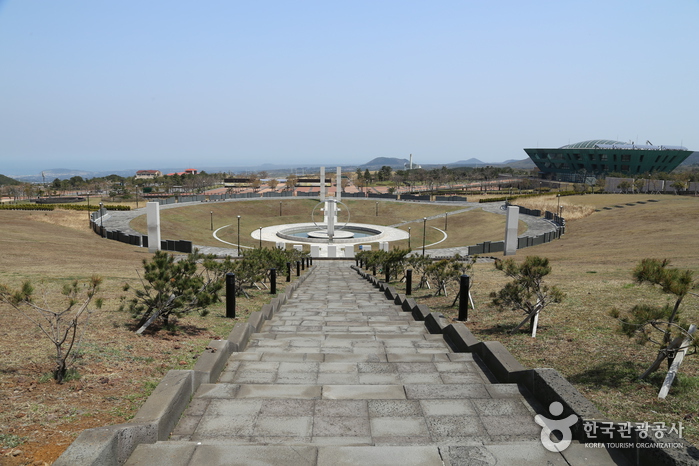
Mankind tends to only remember the heroes of civilization. Jeju 4.3 Peace Park was created to remember those who fell protecting their homeland during the Jeju uprising which broke out on April 3, 1948. The park is the symbol of reconciliation and peace, and seeks to open a new chapter of life.
The development project of Jeju 4.3 Peace Park was a result of the reparations for the victims of the Jeju uprising. The 4.3 Special law was promulgated in the year 2000, and the following steps proceeded: property acquisition for the park, master plan of the park establishment, design competitions for the park, construction, exhibits and installations. It finally opened to the public on March 28, 2008.

Jeju Myeongdoam Youth Hostel (제주 명도암유스호스텔)
12.5Km 15365 2020-03-17
393, Myeongnim-ro, Jeju-si, Jeju-do
+82-64-759-9596
Jeju Myeongdoam Youth Hostel is located near the trail chosen as one of the top 10 most beautiful trail as well as many attractions. Its central location offers traveling convenient for its guests and rooms are arranged in family to dormitory styles to accomodate varying group sizes. Nearby destinations include Jungmun Resort, Jeju City Hall and Cheonjiyeon Falls.
![Hallasan Mountain [National Geopark] (한라산 (제주도 국가지질공원))](http://tong.visitkorea.or.kr/cms/resource/25/2675025_image2_1.JPG)
Hallasan Mountain [National Geopark] (한라산 (제주도 국가지질공원))
12.5Km 435162 2022-11-30
2070-61, 1100-ro, Jeju-si, Jeju-do
+82-64-710-3945
Hallasan Mountain stands proudly at the center of Jeju Island and is perhaps the island’s most memorable landmark. Also called Yeongjusan Mountain, meaning "mountain high enough to pull the galaxy," Hallasan Mountain is widely known by scientists for its geological value. Designated as a national park in 1970, there are 368 parasitic cones called "oreum" (Jeju dialect meaning peak) around the main mountain.
Hallasan Mountain is famous for its vertical ecosystem of plants that results from the varying temperatures along the mountainside. Over 1,800 kinds of plants and 4,000 species of animals (3,300 species of insects) have been identified; to explore the mountain's treasures, simply follow one of the well-developed hiking trails.
Hallasan Mountain Trekking (한라산 트레킹)
12.5Km 111319 2020-06-25
2070-61, 1100-ro, Jeju-si, Jeju-do
+82-64-740-6000
Situated on the southern tip of the Korean Peninsula, Hallasan is 1,950 meters in x_height and is the highest mountain in South Korea. Formed from volcanic activity, the mountain is a dormant volcano made mostly of basalt. Home to the magnificent Baekrokdam (lake-filled crater), the mountainside is covered with alpine flora and lush trees.
The mountain is characterized by majestic cliffs, steep slopes, interesting rock formations, and, in particular, myriads of colorful azaleas. There are over 360 small mountains (uniquely-shaped volcanic mountains called “Oreum” in Jeju dialect) surrounding Halla Mountain that offer new delights to visitors with the coming of each new season. Along with Hallasan, the oreums were officially named the Hallasan Natural Protection Area (Natural Monument No.12) in 1966.
There are six hiking trails along Hallasan. Seongpanak Trail on the east and Gwaneumsa Trail in the north go all the way up to the summit (Baekrokdam). Those looking for a less rigorous hike are advised to take the shorter trails reaching midway up the mountain. All trails are relatively short (less than 10 kilometers) and can be hiked in less than a day. Visitors are advised, however, to start early in the morning if planning on hiking up to the summit and to check official operating hours, as some trails are only open during certain hours of the day. Keep reading for information on some of the most popular trails.
* Gwaneumsa Trail (North)—Summit Trail
Gwaneumsa Trail offers hikers the best view of Hallasan’s deep valleys and stunning terrain. Midway along the trail is Guringul (a lava cave) and Tamna Valley. Tamna Valley is especially beautiful during the fall when the leaves are changing and during the winter when the entire area lays under a dusting of snow.
* Seongpanak Trail (East)—Summit Trail
This relatively long, gently sloping trail is perfect for beginners. Lush broadleaf trees give shade from the beating sun and in spring the azaleas bloom and turn the mountainside into a dazzling array of color.
* Eorimok Trail (Northwest)
This short trail is another relatively easy trail for beginners. In spring, the nearby meadows are adorned with red royal azaleas. From the stone pathway to Mansedongsan visitors can catch a breathtaking panoramic view of the countryside and the island’s signature Oreums.
* Yeongsil Trail (Southwest)
As the shortest trail in Hallasan, this trail boasts Yeongsilgiam (a spectacular cliff with series of unusual rock formations). It is covered with azaleas and royal azaleas in spring and vibrant autumn foliage starting in October.
Jeju Island Special Tourist Zone (제주도 관광특구)
12.7Km 21458 2024-03-15
Jeju-do
+82-64-740-6000
Located to the southwest of the Korean Peninsula, the island of Jeju is Korea's largest tourist destination. The entire island has been designated as a special tourist zone, and it's easy to see why: there is hardly any spot on the island that is not photogenic. Unlike mainland Korea, which has a temperate climate, Jeju boasts a climate that is closer to subtropical. Hallasan Mountain, lying at the center of the island, is surrounded by 368 parasitic cones, known as "Oreum." Eleven beaches have been designated as tourist beaches, but including those that are not officially designated, the island features nearly thirty beaches in total. Famous beaches include Iho Tewoo Beach, Samyang Beach, Hyeopjae Beach, Geumneung Beach, and Gwakji Beach. Jeju's renowned Olle Trails, a system of hiking paths, span a total length of 425 kilometers and would take about fifteen days to complete in their entirety.
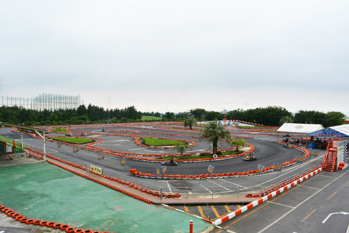
Jeju Leports Land (제주레포츠랜드㈜)
12.9Km 1278 2022-12-29
47 , Waheulsangseo 2-gil, Jeju-si, Jeju-do
Jeju Leports Land is located on the eastern side of Jeju Island and is the country's largest kart experience center. It is a multi-complex leisure experience center with programs such as mountain buggy, zip line, survival field, four season sledding, and more. There are also accommodation facilties such as pensions and guest houses.
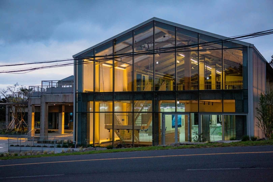
House of Refuge (하우스오브레퓨즈)
13.1Km 0 2024-07-24
735 Haso-ro, Aewol-eup, Jeju-si, Jeju-do
House of Refuge is a large culture complex featuring a cafe and artwork together. The menu includes unique items using local products, such as Jeju banana pudding, and Jeju Nouveau non-alcoholic beer. The space is the perfect setting for exhibitions, parties, performances, and other events.
 English
 한국어
한국어 日本語
日本語 中文(简体)
 Deutsch
 Français
 Español
 Русский