
Jeju National University Hospital (제주대학교병원)
18.6Km 2025-10-23
15 Aran 13-gil, Jeju-si, Jeju-do
Jeju National University Hospital is the only national university hospital in Jeju Island. We serve as the center of public healthcare in the region through education, research, and diagnosis. We are also contributing to the improvement of healthcare and leading the development of the medical industry. In other words, we are a pivotal institution responsible for the island's healthcare.
We are committed to achieving both quantitative and qualitative growth as a leading smart hospital. For example, we are attracting various specialized centers, introducing state-of-the-art equipment, recruiting excellent medical staff, and building a future medical information system.
In addition, Jeju Island has a beautiful natural environment and many places to see, so patients can freely enjoy sightseeing after receiving treatment.
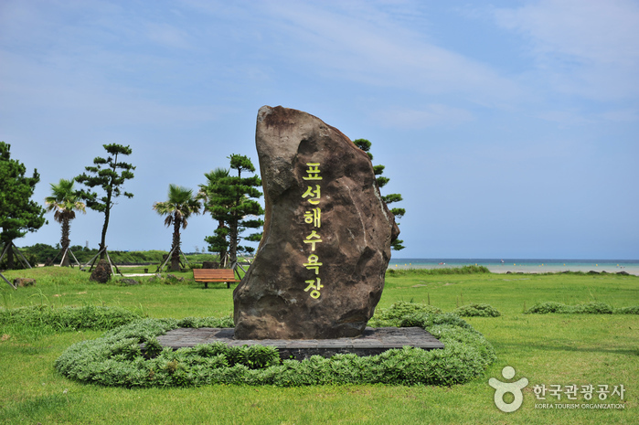
Pyoseon Haevich Beach (표선 해비치 해변)
18.6Km 2025-01-08
Minsokhaean-ro, Seogwipo-si, Jeju-do
+82-64-740-6000
Pyoseon Beach in Seogwipo is a spacious beach, taking up more than 150,000 m². During low tide, the beach looks like an elegant circle, and it becomes a circular lake less than 1 meter deep during high tide, and displays many different colors. The beach is a great place for children to play and for watching the sunrise. The sand on the beach is formed out of broken shells, and sand baths are believed to be effective for people suffering from neuralgia. Every August, this beautiful beach hosts the Pyoseon White Sand Festival, which offers fun and colorful events. The beach is equipped with excellent amenities (a campground, abundant parking space, dressing rooms and shower rooms) and surrounded by nearby attractions, such as Seongeup Folk Village and Jeju Folk Village Museum.
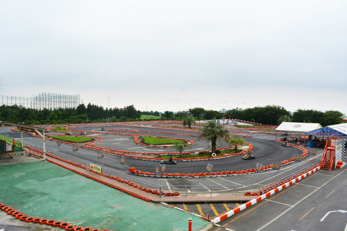
Jeju Leports Land (제주레포츠랜드㈜)
18.7Km 2022-12-29
47 , Waheulsangseo 2-gil, Jeju-si, Jeju-do
Jeju Leports Land is located on the eastern side of Jeju Island and is the country's largest kart experience center. It is a multi-complex leisure experience center with programs such as mountain buggy, zip line, survival field, four season sledding, and more. There are also accommodation facilties such as pensions and guest houses.
![Olive Young - Jeju National University Hospital Branch [Tax Refund Shop] (올리브영 제주대학병원)](http://tong.visitkorea.or.kr/cms/resource/02/2889502_image2_1.jpg)
Olive Young - Jeju National University Hospital Branch [Tax Refund Shop] (올리브영 제주대학병원)
18.7Km 2024-04-18
#102, 616, Jungang-ro, Jeju-si, Jeju-do
-
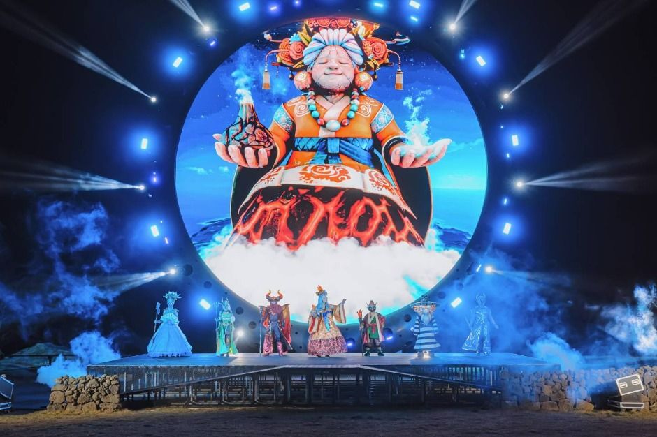
Lumiverse: Island of Light (빛의 섬 루미버스)
18.9Km 2025-07-14
631-34 Minsokhaean-ro, Pyoseon-myeon, Seogwipo-si, Jeju-do
Lumiverse: Island of Light is an evening theme park set in a Jeju folk village as a local-hip cultural entertainment attraction. A gigantic multimedia show and characters inspired by Jeju's folklore bring the night alive. The attraction's name is a portmanteau of "Lumi," wich means light in Latin, and "-verse" from the word "univserse," and is a brand that aims to recreate Jeju's mythical world with lights and arts. Visitors are invited to enjoy the evening with Jeju's mythical gods and goddesses, including the legendary guardian goddess Elderly Mago. The attraction is divided into seven illuminated themed zones, each focusing on one of the seven gods and goddesses. Each theme is decorated using lights, artworks, sound effects and narratives that are sure to enchant one's mind.
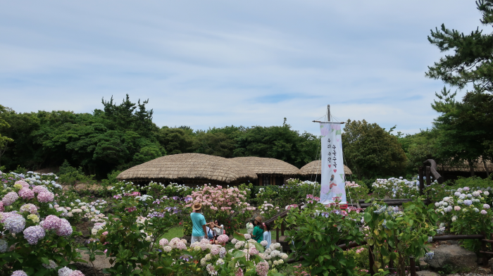
Jeju Folk Village (제주민속촌)
18.9Km 2025-03-17
631-34 Minsokhaean-ro, Pyoseon-myeon, Seogwipo-si, Jeju-do
Jeju Folk Village reproduces the old life of Jeju in the 19th century. More than 100 traditional Jeju houses and folk culture are being recreated and exhibited through archival research. The village is planted with local trees and flowers from Jeju and Korea, so visitors can enjoy flowers in all seasons. It features themed exhibition halls, model houses, and traditional folk games, attracting numerous visitors.
Haevichi Hotel & Resort Jeju (해비치 호텔&리조트 제주)
19.1Km 2025-09-16
537, Minsokhaean-ro, Seogwipo-si, Jeju-do
+82-64-780-8100
Haevichi Resort is a luxury condo-style resort operated by Hyundai Group set within the cultural and natural landscape of Pyoseon on the eastern coast of Jeju Island. Rooms offer views of Hallasan Mountain and the ocean, as well as the 36-hole golf course, open to guests year-round. Additional amenities include an outdoor heated swimming pool, eight restaurant & bars, and children's entertainment facilities.
Secret Forest (비밀의 숲)
19.1Km 2025-10-28
2173,Songdang-ri, Jeju-si, Jeju-do
+82-10-4864-4609
Secret Forest, located in Gujwa-eup, Jeju-si, is a natural forest path that became famous as a must-visit selfie spot on social media. It shows its own unique appeal different from that of other well-known forests on Jeju Island such as Bijarim Forest and Saryeonisup Forest Trail. It consists of diverse elements from the rare cypress forest and vast grassland to stone walls and log cabins, and also features photo spots that contain sentiments and vibes unique to Jeju Island. Here, visitors can enjoy the beautiful four seasons of nature through canola blossoms and pink muhly. However, since it is a privately-owned land, it is prohibited to take pictures in the area until completely passing through the entrance, and must refer to the address shown on the website to get to the paved road.
Joanne Bear Museum (조안베어뮤지엄)
19.3Km 2022-10-13
113, Daepo-ro, Seogwipo-si, Jeju-do
+82-64-739-1024
Joanne Bear Museum located in Jungmun Resort Complex in Seogwipo-si, on Jeju-do Island is a gallery exhibition hall for Joanne Oh, a world-famous teddy bear artist. The museum, which boasts the motto “nature and environmentalism", showcases teddy bears that are made of all-natural materials. The eco-friendly pieces mimic the natural beauty of Jeju Island and give visitors a feeling of comfort and refreshment.
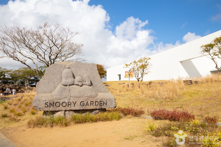
Snoopy Garden (스누피가든)
19.5Km 2024-10-29
930 Geumbaekjo-ro, Gujwa-eup, Jeju-si, Jeju
+82-64-903-1111
Snoopy Garden House is where visitors can meet Snoopy and friends from the popular American comic series "Peanuts." The themed halls designed under the overall theme of "Peanuts, Nature & Life" allows one to connect their everyday life through episodes from "Peanuts." Snoopy Garden House has a total of five themed halls and Peanuts Store.
 English
 한국어
한국어 日本語
日本語 中文(简体)
 Deutsch
 Français
 Español
 Русский