Gunnam Flood Control Theme Park (군남홍수조절지 두루미테마파크)
12.4Km 2023-09-20
Gunnam-myeon, Yeoncheon-gun, Gyeonggi-do
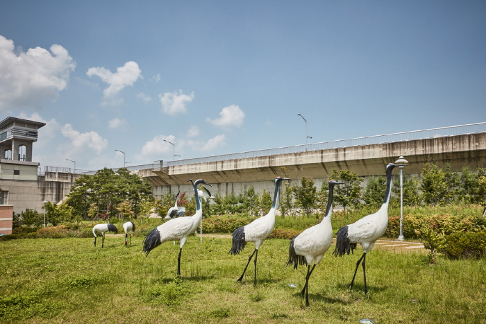
The Gunnam Flood Control Site is situated near the border between North and South Korea just six kilometers away from the demarcation line. More than 97% of the land around the Gunnam flood control dam is part of North Korea. The site is effective in controlling the flooding of the Imjingang River and improving irregular water flow. This area is a key wintering site for various migratory birds such as white-naped cranes, and hooded cranes, with up to 200 birds spending every winter in the area. Given the unique characteristics created by the geographical condition of the area near the border between South and North Korea and the natural environment of the Imjingang River, the site is a great natural ecological habitat for various wildlife.
The Gunnam Flood Control Theme Park features “The Story of Peace and Love told by Cranes” as its theme. Various story-telling facilities are installed, such as the drum of peace, a wishing tree, and crane structures. There are also outstanding facilities to minimize impact on the environment, such as an alternative habitat for cranes, fishway ecology, and ecological wetlands. The facility makes it a great place to learn about and experience ecology.
![Jiktangpokpo Falls [National Geopark] (직탕폭포 (한탄강 국가지질공원))](http://tong.visitkorea.or.kr/cms/resource/70/1137370_image2_1.jpg)
Jiktangpokpo Falls [National Geopark] (직탕폭포 (한탄강 국가지질공원))
12.4Km 2021-09-25
94, Jiktang-gil, Cheorwon-gun, Gangwon-do
+82-33-450-5534
Jiktangpokpo Falls is location in the middle of Hantangang River, which runs through town of Dongsong-eup in Cheorwon. Unlike other falls, Jiktangpokpo Falls is not tall, but wide instead as the 3 meter-high falls stretch almost 60 meters from bank to bank. Widely known for its grandeur and beauty, Jiktangpokpo Falls is one of the 8 scenic wonders of Cheorwon. It is an ideal summer vacation spot and visitors can enjoy the savory maeuntang (spicy seafood stew) made with freshwater fish at one of the many restaurants located in the vicinity.
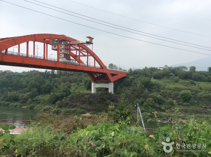
Hantangang Bungee Jump Korea Leisure (한탄강번지점프(코리아레저))
12.5Km 2024-03-20
153 Taebongdaegyo-gil, Galmal-eup, Cheorwon-gun, Gangwon-do
Taebongdaegyo Bridge, towering over the Hantangang River, serves as the starting point for Ice Trekking programs in winter. During the summer, it transforms into a bungee jumping site. The platform, elevated 52 meters above sea level, offers a truly exhilarating drop. This site also provides a spectacular view of the Hantangang River’s beautiful valleys.
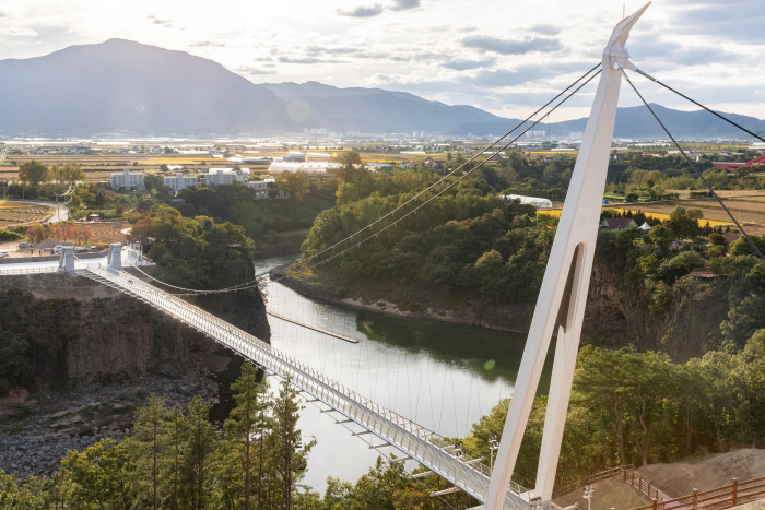
Cheorwon Hantangang Milky Way Bridge (철원 한탄강 은하수교)
12.9Km 2023-03-07
725-12, Jangheung-ri, Cheorwon-gun, Gangwon-do
+82-33-450-5365
The area of Hantangang River is a UNESCO Global Geopark. The Milky Way Bridge was built to follow a natural path and allows visitors to journey comfortably. The name of the bridge takes from the famous Hantangang River and region of Cheorwon and adds eunhasu, or Milky Way, the path made of stars.
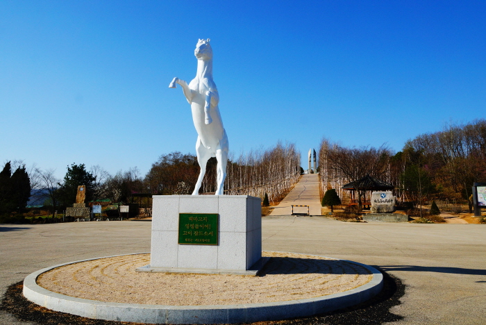
Memorial Tower of Baengmagoji Battlefield and Memorial Museum (백마고지 위령비와 기념관)
12.9Km 2025-10-23
72, Daema 1-gil, Cheorwon-gun, Gangwon-do
+82-33-450-5559
Located in the northern area of South Korea, Baengmagoji Battlefield was one of the bloodiest battlefields during the Korean War. The communist Chinese army launched a major offensive attack for 10 days on October 6, 1952 during the Battle of Baengmagoji, which can be translated into the Battle of White Horse Highlands. Due to this battle, the communist Chinese army suffered around 14,000 casualties and the army completely collapsed while the 9th Infantry Division won the Battle of Baengmagoji and got the nickname “White Horse.”
After the battle, the area gave off a bad smell because of the dead bodies. The mountain area lost its original shape due to the severe battle and as a result the area was named “Baengmagoji” as it was said to resemble a white horse (baengma) lying down.
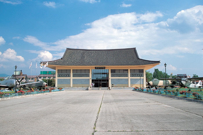
Cheorwon Facilities Management Office (Formerly, Iron Triangle Battlefield (철원 시설물관리사업소 (구 철의삼각전적관))
13.1Km 2025-03-15
1825, Taebong-ro, Cheorwon-gun, Gangwon-do
+82-33-450-5559
Located in Goseokjeong National Tourism Site, Cheorwon Facilities Management Office is the main tourism center hosting the Cheorwon tour. Starting from Security Tourist Site Development Plan by Cheorwon-gun county in 1976 , the Ministry of Transportation designated Goseokjeong as Goseokjeong National Tourist Area in 1977. The military and Cheorwon-gun county carried out security and battlefield excavation and preservation projects, and established a security educational site featuring the national largest scale in 1985.
Presently, the Iron Triangle Battlefield, located in Goseokjeong National Tourist Area, is used as a security educational site. Unification Hall found within houses various exhibitions, giving information to compare with current and past lifestyles and military devices including varied aircrafts displayed in the outdoor exhibition area. In the educational hall, a promotional video for Cheorwon is screened. Likewise, the exhibition hall covers various materials that allow one to think about unification between North Korea and South Korea.
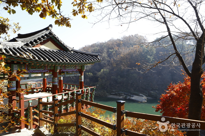
Goseokjeong National Tourist Area (고석정국민관광지)
13.1Km 2023-03-07
1825, Taebong-ro, Cheorwon-gun, Gangwon-do
+82-33-450-5558
Goseokjeong Pavilion is the most scenic spot among the eight scenic views of Cheorwon. The crystal clear waters of the Hantangang River wind around Goseokbawi Rock, a peculiarly shaped rock about 10 meters tall that stands dominantly in the middle of the river. Goseokjeong Pavilion is a two-story tower-style pavilion that has an area of about 33 square meters, built halfway up the Hantangang River during the reign of King Jinpyeong (r. AD 579-632) of the Silla Kingdom. Today, Goseokjeong refers to the entire area around Goseokjeong Pavilion and the valley surrounding Goseok Rock. Designated as a Monument of Gangwon-do, the pavilion is known to have been one of the most favored places by King Jinpyeong of the Silla Kingdom, and King Chungsuk of the Goryeo dynasty. The area became all the more famous as the arena of Im Kkeok-jeong (?-1562), who was a legendary leader of a peasant rebellion in the early Joseon dynasty.
The pavilion was destroyed during the Korean War and restored in 1971 by community leaders in Cheorwon. Unfortunately, it was damaged once again by flood in 1996 and reconstructed the year after. There is a natural stone chamber inside Goseokbawi Rock that Im Kkeok-jeong used as a hiding place. On the opposite side, there are remains of a stone castle. Jiktang Waterfall is located about 2 kilometers up from this site, while Sundam Valley is situated about 2 kilometers in downstream. Goseokjeong is a year-round tourist attraction with an extensive grass square and recreational facilities. It is also the starting point for DMZ tours as the Iron Triangle Battlefield Conservation Office is located here and in winter, visitors can enjoy migratory bird tours.
![Hantangang River [National Geopark] (한탄강(국가지질공원, 고석정))](http://tong.visitkorea.or.kr/cms/resource/52/2675252_image2_1.jpg)
Hantangang River [National Geopark] (한탄강(국가지질공원, 고석정))
13.4Km 2022-06-02
1825 , Taebong-ro, Cheorwon-gun, Gangwon-do
+82-33-450-4810
Goseok Rock, located in the area of Hantangang River, is a granite rock that reach 15 meters in x_height. The area is often called Goseokjeong, named after the nearby Goseokjeong Pavilion. The area is an important geology and topography learning site where it is visible to see the topography before the formation of the basalt lava field and the fact that the basalt lava flowed over the bedrock to form the lava field. Goseok is a bedrock that existed before the area of Cheorwon was covered with lava, and is a granite formed underground about 110 million years ago (mid Cretaceous period). It is covered in basalt lava by volcanic activity that occurred between about 540,000 and 120,000 years ago, and then eroded by the Hantangang River to form a new waterway.
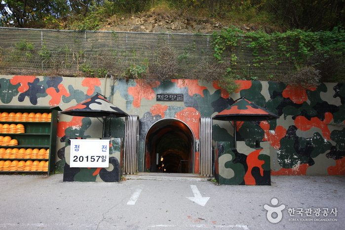
The 2nd Tunnel (제2땅굴(철원))
13.4Km 2024-03-20
Yangji-ri, Dongsong-eup, Cheorwon-gun, Gangwon-do
+82-33-450-5559
The 2nd Tunnel, one of several excavated by North Korea for the purpose of infiltrating South Korea, was discovered in 1975. Spanning a total length of 3.5 kilometers, only 500 meters of the tunnel is accessible to civilians. To visit this site, visitors are required to book as part of the DMZ Peace Tours. Additionally, personal identification, such as a passport or Alien Registration Card (ARC), is necessary for access.
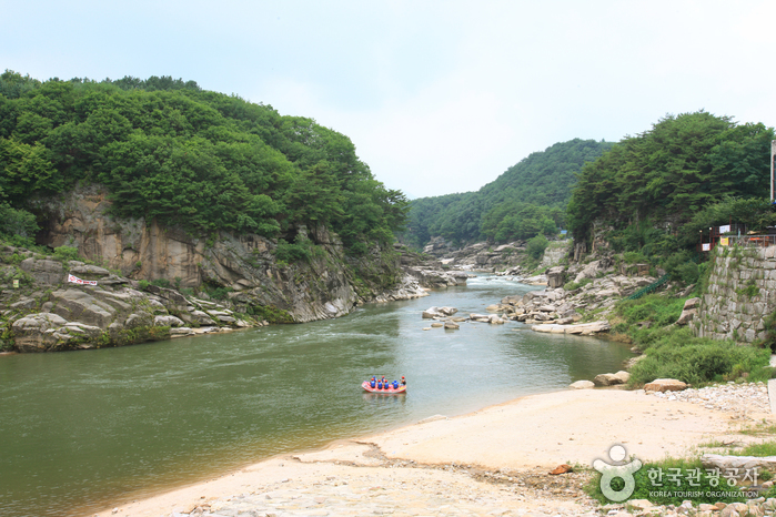
Sundamgyegok Valley (순담계곡)
13.8Km 2025-01-07
143-3, Sundam-gil, Cheorwon-gun, Gangwon-do
+82-33-450-5365
Located 5 kilometers northwest of Cheorwon-gun Office, Sundamgyegok Valley is one of the most beautiful valleys among the branches of the Hantangang River. It offers fantastic scenery of fascinating rock formations, steep cliffs, and ponds. The valley is filled with abundant water, trimmed by rare naturally white sand. Also, the stream behind the valley attracts many rafters each year.
 English
 한국어
한국어 日本語
日本語 中文(简体)
 Deutsch
 Français
 Español
 Русский