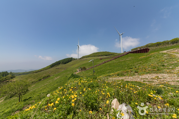
Pyeongchang Yukbaekmajigi (평창 육백마지기)
13.2 Km 0 2023-03-07
583-76, Cheongoksan-gil, Pyeongchang-gun, Gangwon-do
+82-33-330-2771
Yukbaekmajigi refers to the peak of Cheongoksan Mountain on the southern side of Pyeongchang-gun, Gangwon-do. The large field is the size of six soccer fields and is 1,256 meters above sea level. The name comes from the saying that the field is large enough to spread 600 mal (Korean unit of measure) of rice seeds. Yukbaekmajigi is easy to reach by car and is becoming a popular eco-friendly tourist attraction. The view from the peak includes an open view of 20 large wind power generators on the vast field. There are also various photo zones for visitors.
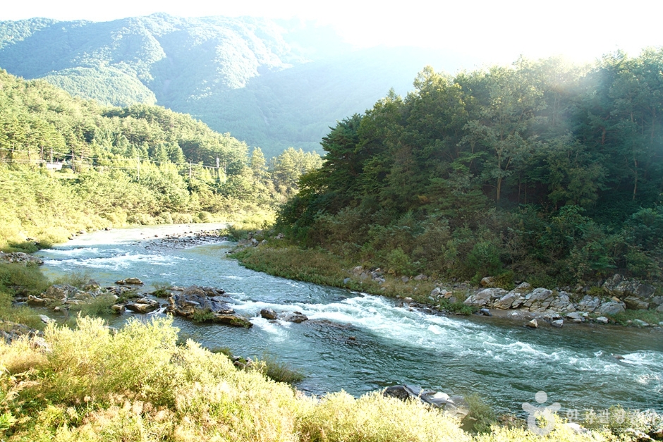
Sugamgyegok Valley (숙암계곡)
13.4 Km 36650 2024-02-28
Danim-gil, Bukpyeong-myeon, Jeongseon-gun, Gangwon-do
Sugamgyegok Valley, stretching 10 kilometers long, meanders around Sangwonsan and Gariwangsan Mountains. The roads flanking the valley are favored destinations for scenic drives. One of the valley's key features is the Sugamsaem Spring, known for its clear and cold water. Upstream, a 20-meter-tall waterfall stands as a prime attraction, complemented by the historical Sugamseowon Confucian Academy. The valley is lush and verdant in spring, transforming into a vibrant display of red fall colors in autumn. Visitors can follow the hiking trails to fully immerse themselves in the stunning scenery of the valley.

Baengnyongdonggul Cave-Gangwon Paleozoic Geopark (백룡동굴-강원고생대 국가지질공원)
13.5 Km 13092 2020-06-10
63, Munhui-gil, Pyeongchang-gun, Gangwon-do
+82-33-560-2379
Baengnyongdonggul Cave is a 1.8㎞-long, natural limestone cave located in Pyeongchang-gun, Gangwon-do. The cave entrance is located 10-15㎞ above sea level, and is surrounded by rocks. In 1976, local residents expanded a small lane in the middle of the main cave corridor to allow for easier exploration. Since then, the cave has continued to be explored and researched with great value for geologists. The cave was designated Natural Monument No. 260 in 1979.
Pyeongchang Eoreumchi Village (평창 어름치마을)
14.3 Km 12034 2024-02-16
42-5 Maha-gil, Mitan-myeon, Pyeongchang-gun, Gangwon-do
Pyeongchang Eoreumchi Village is dedicated to preserving the habitat of the Eoreumchi (Cyprinid Fish), a natural monument that thrives in pristine environments. The village offers immersive rural experiences and ecotourism activities. Visitors have the opportunity to engage in water sports like rafting and kayaking on the Donggang River, as well as mountain climbing on Baegunsan Mountain. Other activities include trekking through Chiljokryeong and exploring the Baengnyongdonggul Cave. Reservations for these experiences can be made through their website.
Jeongseon Morundae Cliff (몰운대 (정선))
15.1 Km 11167 2021-05-31
1330, Yaksu-gil, Jeongseon-gun, Gangwon-do
+82-1544-9053
Morundae Cliff is one of the Eight Scenic Sites of Hwaam. The tip of the steep cliff is adorned with three specimens of 500-year-old pine trees. Legend has it that gods would perch on the cliff’s top and enjoy the beautiful view. At the foot of the cliff lies a large sheet of rock that can accommodate hundreds of people.
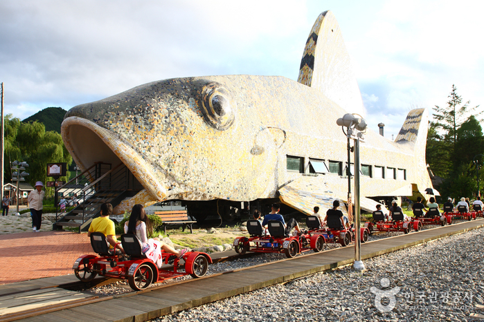
Jeongseon Railbike (정선레일바이크)
16.5 Km 18972 2022-12-23
745, Nochusan-ro, Jeongseon-gun, Gangwon-do
+82-33-563-8787
Jeongseon Railbike was the first railbike location to open in Korea. Offering both two- and four-person bikes, riders depart from Gujeol Station and travel 7.2 kilometers along an abandoned railway track to Auraji Station. The tracks pass along the clean river, through a forest, and through old train tunnels decorated with vibrant lights.
The track of Jeongseon Railbike is relatively flat, making it easy for all riders to enjoy the passing scenery in comfort. The full track takes about 30~40 minutes to complete. After arriving, visitors can hop aboard the train that takes riders back to Gujeol Station. There are cafes at Gujeol and Auraji Stations designed to look like a grasshopper and a fish, respectively. These train cafes make for great photos! The Ant Pension also is fun, designed just like an ant.
Mindungsan Mountain (민둥산)
17.5 Km 49838 2022-12-26
12, Mindungsan-ro, Jeongseon-gun, Gangwon-do
+82-1544-9053
Situated in Jeongseon, Gangwon-do, Mindungsan Mountain (1,118.8 meters) is an unusual site when compared to other national peaks. As hinted by its name's meaning "bare mountain," there are few trees near its summit. Locals also refer to it as Eoksaesan (silver grass) Mountain because of the waves of eulalia covering its sides. The mountain remains this way because villagers burned the fields once a year to encourage the growth of wild herbs.
The mountain’s gradual slope offers an enjoyable trekking experience for hikers of all levels. In mid-October, waist-high silver grass is indeed everywhere, making it challenging for hikers to view the surrounding areas. Fortunately, certain spots near the peak offer breathtaking views of the gentle ridges and flowing hillsides.
Silver grass begins blooming in September and reaches peak colors between October and November. The Silver Grass Festival is held on Mindungsan Mountain every October, attracting hundreds of thousands of attendees for a wonderful outdoor hiking experience and picturesque photo opportunities. The mountain is easily accessible by train allowing visitors from near and far to enjoy the fall colors.
On the outskirts of Mindungsan Mountain near Balgudeok village is Goebyeonggol Valley, which contains magnificent rock formations and limestone caves. Other nearby attractions include Hwaam Yaksu (spring water site), Auraji Naruteo famous for creating Jeongseon Arirang (a local version of the traditional folk song, Arirang), and Gariwangsan Mountain (known for wild ginseng).
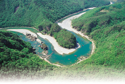
Eorayeon Valley -Gangwon Paleozoic Geopark (어라연-강원고생대 국가지질공원)
19.5 Km 8440 2022-12-29
259 , Eorayeon-gil, Yeongwol-gun, Gangwon-do
+82-33-372-1705
A beautiful and mysterious valley located 12 km up the Donggang River, Eorayeon Valley is renowned for its clean waters and for the many fish that inhabit it. The valley has beautiful rock formations and a dense pine forest that were designated as the National Scenic Spot in December 2004. It is one of Korea's most popular sites for rafting, followed by Naerincheon Creek and Cheorwon's Hantangang River. The trail to Eorayeon through Jatbong Peak is also quite popular (approx. 3 hours).
 English
 한국어
한국어 日本語
日本語 中文(简体)
 Deutsch
 Français
 Español
 Русский