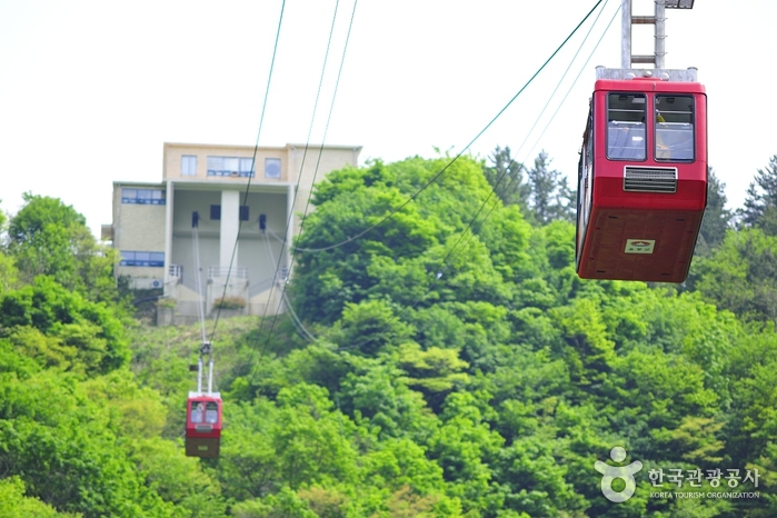
Dokdo Island Observatory Cable Car (독도전망대 케이블카)
1.6 Km 11740 2021-10-02
Dodong-ri, Ulleung-gun, Gyeongsangbuk-do
+82-54-790-6427
The Dokdo Island Observatory Cable Car, from which one can get a bird's eye view of Ulleungdo Island, is a must-see tourist attraction. Located inside the Dodong Yaksu Park, the cable car takes visitors up to Manghyangbong Peak. When the sky is really clear (about 50 days a year), you can see as far as Dokdo Island that is located 92 kilometers away. This is also the first place to view the rising sun in Ulleungdo Island.

Ulleung Marina Tourist Hotel (울릉 마리나 관광호텔)
2.3 Km 14001 2021-03-25
44-28, Sadong 2-gil, Ulleung-gun, Gyeongsangbuk-do
+82-54-791-0020
Located within the tourist resort area in Hubakgol, Sadong-ri, the Ulleung Marina Tourist Hotel sits at 150 meters above sea level, 500 meters away from the ocean. As such, it is protected from strong sea winds and the salty air. Visitors can relax and enjoy a refreshing walk in the woods all year round.
![Bongnaepokpo Falls [Ullengdo & Dokdo National Geopark] (봉래폭포 (울릉도, 독도 국가지질공원))](http://tong.visitkorea.or.kr/cms/resource/28/1893628_image2_1.jpg)
Bongnaepokpo Falls [Ullengdo & Dokdo National Geopark] (봉래폭포 (울릉도, 독도 국가지질공원))
3.1 Km 13284 2024-02-23
Dodong-ri, Ulleung-eup, Ulleung-gun, Gyeongsangbuk-do
+82-54-790-6182
Nestled within the picturesque mountains of eastern Ulleungdo Island, Bongnaepokpo Falls stands as a majestic 30-meter high waterfall. Its formation traces back to the cooling of rocks following a volcanic eruption. This lush region is richly wooded, offering a delightful opportunity for a forest bathing during your hike. Moreover, the deck situated just beneath the waterfall serves as an ideal spot for capturing stunning photographs. Even in the heat of summer, the area remains pleasantly cool, thanks to the gentle breeze that naturally flows through the openings.
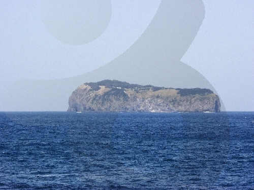
Ulleung Jukdo Island (죽도(울릉))
4.8 Km 28016 2021-07-30
59-9, Jukdo-gil, Ulleung-gun, Gyeongsangbuk-do
+82-54-790-6454
Jukdo Island is a small inhabited island near Ulleungdo Island, located 4 kilometers apart from Jeodonghang Port and 7 kilometers away from Dodonghang Port, both of which are nestled northeast of Ulleungdo Island. Normally, tourists visit Jukdo Island on their way back to the 'mainland' by taking a ferry service that departs from Dodonghang Port.
The natural environment of Jukdo Island is uncontaminated, thus almost everything is so pristine to the extent that people can even collect rainwater to drink, much thanks to its geological and cultural distance from the more modernized parts of Korea.
![Seonginbong Primeval Forest [National Geopark] (성인봉 원시림 (울릉도, 독도 국가지질공원))](http://tong.visitkorea.or.kr/cms/resource/57/2370057_image2_1.jpg)
Seonginbong Primeval Forest [National Geopark] (성인봉 원시림 (울릉도, 독도 국가지질공원))
5.1 Km 10938 2021-04-23
Namyang-ri, Ulleung-gun, Gyeongsangbuk-do
+82-54-790-6182
The foot of Seonginbong Peak is covered with thick primeval forests designated as Natural Monument No. 189. This forest is Ulleungdo Island's only flat area with a diameter of approximately 2 kilometers. It is a caldera formed by volcanic activities and developed over time. The area has many rare plants only found in Ulleungdo Island.
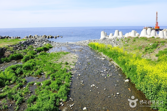
Tonggumi Pebble Beach (통구미몽돌해변)
5.7 Km 14433 2021-10-25
Ulleungsunhwan-ro, Ulleung-gun, Gyeongsangbuk-do
+82-54-790-6454
At Tonggumi Pebble Beach on Ulleungdo Island, you can enjoy the views of impressive sea-side cliffs, the glittering ocean, and the dark pebbles that dot the landscape, all at once. There are always waves at this 1-kilometer-long beach with waters ranging in depth from 1 to 3 meters. It is easy to find the beach, as it is located along the Ulleungdo Coastal Drive. Various facilities such as bathrooms, parking lots, homestays, restaurants, drugstores, supermarkets and accommodations are found near the beach.
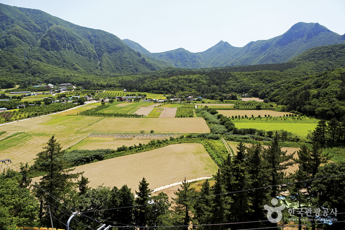
Nari Basin (나리분지)
5.8 Km 13184 2021-05-13
Nari-gil, Ulleung-gun, Gyeongsangbuk-do
+82-54-790-6423
Originally a caldera formed on the northern Seonginbong Peak, Nari Basin is the only flatland on Ulleungdo Island. The lava flow from the volcanic eruption created two other craters, which were turned into Nari Village in the northeast and Albong Village, now uninhabited, in the northwest. Records were found that the island was inhabited since the Usan-guk period, but the islanders had to move out of the island in the earlier Joseon period until a new settlement policy was enforced later on.
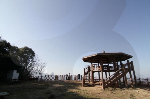
Seokpo Observatory (석포전망대)
5.9 Km 6107 2020-03-24
Cheonbu-ri, Ulleung-gun, Gyeongsangbuk-do
+82-54-790-6392
Seokpo Observatory is located in Seokpo village, a small fishing town at the northernmost point of Buk-myeon on Ulleungdo Island.
Ulleungdo Island has three popular scenic lookouts, one of which is Seokpo Observatory to the north. Created in 1905, the observatory was used by the Japanese through 1945 to monitor movements of Russian warships.
Seokpo Observatory offers views of the East Sea between Ulleungdo and the Korean Peninsula. The observatory has an 8-sided pavilion with lookout deck and telescope from which views of picturesque Jukdo and the majestic coastline of Buk-myeon are available. The area is also nearby the 3 popular attractions of Gongam (an elephant-shaped rock), Gwaneumdo, and Samseonam. Below the observatory is Seokpo Resting Area and a trekking course connecting Seokpo Observatory and Naesujeon Sunrise Observatory.
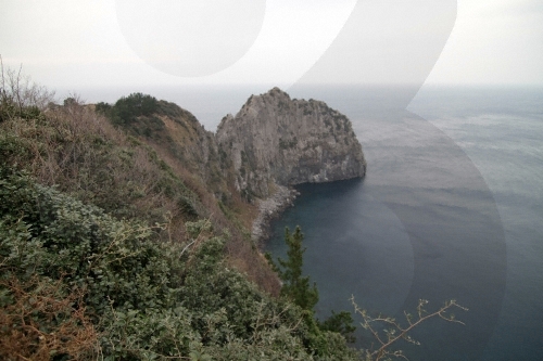
Turtle Rock & Natural Wild Juniper Habitat (거북바위 및 향나무 자생지 (울릉도, 독도 국가지질공원))
6.0 Km 21205 2021-06-29
Taeha-ri, Ulleung-gun, Gyeongsangbuk-do
+82-33-791-2113
Turtle Rock was given its name for its rock formation that resembles the shape of turtles climbing out to the rock. The Turtle Rock is a volcanic rock that formed from the molten lava from Ulleungdo Island's early volcanic activity. Solidified lava flow as well as chilled margins can still be seen along the rock's slope. The western cliff of the rock is Tonggumi Village, where it serves as a home to wild juniper trees. On the northwestern side of the rock is Daepunggam Village, also a natural habitat for wild juniper trees. Both sites were designated as Natural Monuments for their significance. The juniper trees here are known to have a slower growth rate than those under normal condition due to rough winds.
Gwaneumdo Island (관음도)
6.2 Km 0 2024-03-29
Cheonbu-ri, Buk-myeon, Ulleung-gun, Gyeongsangbuk-do
Gwaneumdo Island is the third largest island among the islands around Ulleungdo Island. Gwaneumdo Island was originally connected to Ulleungdo Island, but as a result of being eroded by the sea for a long time, it separated from Ulleungdo Island. There is a suspension bridge between the two islands, so visitors can travel on foot. Gwaneumdo Island has three observatories and two trails (Courses A and B), allowing one to enjoy the scenic highlights of Ulleungdo Island. Also worth seeing are the coastal cliffs of Gwaneumssanggul Twin Caves and the columnar joints that appeared due to cooling lava flows. The scenery with the various seasonal plants is spectacular. Strong winds can cause access restrictions, so it's best to check the Ulleung-gun county government office's website before visiting.
 English
 한국어
한국어 日本語
日本語 中文(简体)
 Deutsch
 Français
 Español
 Русский