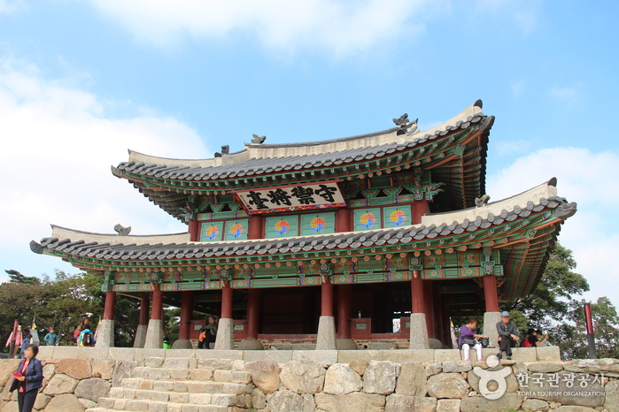
Sueojangdae Post (수어장대)
2020-04-09
107-65, Namhansanseong-ro 780beon-gil, Gwangju-si, Gyeonggi-do
+82-31-760-4821
Sueojangdae Post (Defense Commander's Post) is a two-story military facility used as a lookout post as well as for directing battles. This structure was built on the western side of Namhansanseong Fortress as one of the four command posts. During the Manchu Invasion of 1636, King Injo personally commanded and encouraged the troops from here. They held out for 45 days against a Qing force of 120,000, before finally being forced to surrender and accept vassal status to the Manchu Empire.
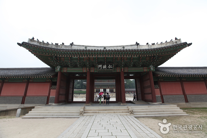
Changdeokgung Injeongmun Gate (창덕궁 인정문)
2025-01-14
99, Yulgok-ro, Jongno-gu, Seoul
+82-2-3668-2300
Serving as the main gate of Injeongjeon Hall, Injeongmun Gate was established in 1405 (5th year of King Taejo’s reign during the Joseon dynasty). Later on, the gate was destroyed by multiple fires during the Imjin War (Japanese invasion of Korea in 1592), therefore current form of the establishment displays designs that are more often seen in the late 19th century's. In addition, a lot
of subsidary marks and buildings are removed from the original places and relocated passing the time, however, still remains to represent prestigious ambience.
Injeongmun Gate served as the place for several coronation ceremonies of kings, prince's succession of throne, and many other national affairs celebrated by the royal members who gathered and aligned around this gate.
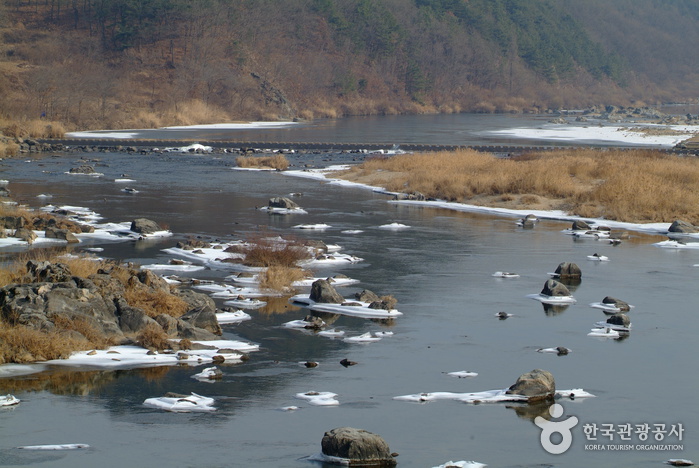
Seomgang River (Seomgang Resort) (섬강(섬강유원지))
2021-01-28
Munye-ro, Hoengseong-gun, Gangwon-do
+82-33-340-2840
Seomgang River crisscrosses the heart of Hoengseong County, flowing on towards Wonju before eventually joining the Namhangang River. The banks of this river are home to a variety of wild flowers, including bright pink royal azaleas that bloom every spring. Gigantic rocks and pine tree forests on each side complete the view. High on the bluff rests Unamjeong Pavilion, overlooking the river and the unfolding vista. Hoengseong's downtown area starts right after crossing Seomgang River on Heongseonggyo Bridge. Nearby attractions like Hoengseong Sports Complex and local resturants specializing in fish stew also attract more tourists to come after sightseeing.
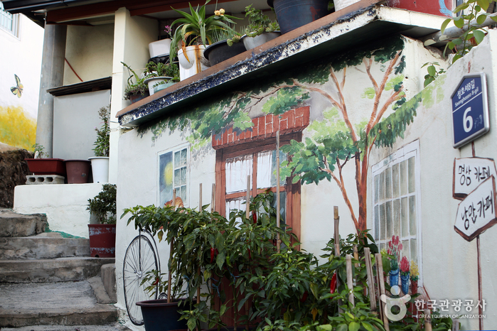
Gagopa Kkoburang-gil Mural Village (가고파 꼬부랑길 벽화마을)
2020-06-02
15-8, Seonghoseo 7-gil, Masanhappo-gu, Changwon-si, Gyeongsangnam-do
+82-55-220-5690
Masan is made more beautiful by Gagopa Kkoburang-gil Mural Village, a local renovation effort made by Gyeongnam Bank. The village is one of the top photo zones. Walking through the village from Chang-dong, past Burim Market, and on to Seongho-dong mountain neighborhood, the colorful murals will bright every step of the way.
Changwon Garosu-gil (창원 가로수길)
2015-10-15
Yongho-dong, Uichang-gu, Changwon-si, Gyeongsangnam-do
Like Seoul, the city of Changwon also has a romantic promenade called "Garosu-gil," lined with metasequoia trees on each side. The street is filled with a lovely ambience, dotted by small and cozy coffee shops, galleries, and art shops, making it the perfect place for a leisurely walk or a tea-time.

Montmartre Park (몽마르뜨공원)
2024-03-20
59 Banpo-daero 37-gil, Seocho-gu, Seoul
+82-2-2155-6860
Montmartre Park, situated above Seorae Village, earns its name due to the significant number of French residents in the vicinity. This small park exudes an atmosphere of art and romance, fitting its namesake. Adorned with poems and sculptures contributed by French poets and artists, the park also features busts depicting renowned figures like Vincent Van Gogh, Paul Gauguin, and Pablo Picasso. Towards the park's conclusion, Nue Bridge connects it to the Seoripul Neighborhood Park.
Gyeonggi Janggyeongsa Temple (장경사(경기))
2025-01-14
676, Namhansanseong-ro, Gwangju-si, Gyeonggi-do
+82-31-743-6548
Janggyeongsa Temple is located in Namhansanseong Fortress. Namhansanseong Fortress, which protected Seoul along with Bukhansanseong Fortress, was built at the same time as Janggyeongsa Temple in 1638, during the 16th year of King Injo. Warrior monks from all eight provinces throughout the country helped with the construction. Janggyeongsa Temple is the only remaining temple among nine such temples where military groups made up of monks stayed for trainings.
Gwangju Gonjiam Ceramic Park (광주 곤지암도자공원)
2021-10-23
727, Gyeongchung-daero, Gwangju-si, Gyeonggi-do
+82-31-799-1500
Located in Sam-ri, Gwangju in Gyeonggi-do, Gwangju Gonjiam Ceramic Park is largely comprised of a historic site from the Old Stone Age Era. This site was where porcelain was made and sold to the royal palace during the Joseon period. The park spans an area of over 6,611 ㎡, consisting of a sculpture park, ceramic shopping mall, cultural hall, performance hall, the Old Stone Age experiential madang, Jungang Lake Square, and other facilities that all visitors can freely enjoy within the park.
Mosaic Park, built based on art works regarding ceramics, and Gyeonggi Ceramic Museum, exhibiting art pieces in sequential order, are the venues for various hands-on programs as well as food culture, outdoor, performances, events and other programs taking place all year round. The park features a multicultural complex that meets every need in tradition, culture, art, education, play, resting and others.
Gochang Munsusa Temple (문수사 (고창))
2024-04-07
135, Chilseong-gil, Gochang-gun, Jeonbuk-do
+82-63-562-0502
Nestled on the slope of Munsusan Mountain (alt. 621 m) in Gochang, Jeollabuk-do and Jangseong, Jeollanam-do, Munsusa Temple is located in the area of a dense mountain ridge to the west of Gosu Kiln Site in Gosu-myeon, and Josan Reservoir. The ridge features clean water and a thick forest that has remained uncontaminated due to its isolated location.
The temple's establishment date is uncertain. The temple houses Daeungjeon Hall (Local Tangible Cultural Heritage No. 51) and Munsujeon Hall (Local Tangible Heritage No. 52), as well as Myeongbujeon and Hansanjeon Halls. Daeungjeon is a small building featuring the unique architecture of gable roofing. Visitors will be fascinated by the temple's scenery, boasting valley waters flowing from dense forests. It is particularly beautiful in fall, when the autumn foliage harmonizes well with the colors of the old temple. The temple grounds are surrounded by a colony of maple trees 100 to 400 years old.
The Forest of Maple Trees at Munsusa Temple, Gochang, was designated in 2005 as Natural Monument No. 463. It covers the area from the entrance of Munsusan Mountain to the entrance of Munsusa Temple with nearly 500 maple trees lining the 80 meter-long path.
Changwon Sangsang-gil Road (상상길 (창원))
2021-01-19
Masanhappo-gu, Changwon-si, Gyeongsangnam-do
+82-55-289-8815
Sangsang-gil Road was created to show the beauty of Korea as imagined by the world. The title of the 150-meter-long road from Buljonggeori Road to Burim Market was given in 2015 after a global internet campaign by Korea Tourism Organization. The road is paved with 23,000 blocks engraved with the names of foreigners in five different colors that represent Korea. The road is also a famous date course with many popular restaurants along the road.
 English
 한국어
한국어 日本語
日本語 中文(简体)
 Deutsch
 Français
 Español
 Русский