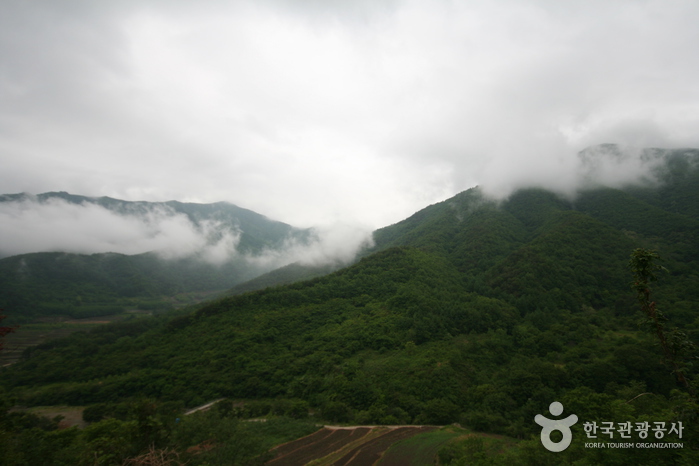
Jirisan National Park (Sancheong) (지리산국립공원(산청))
10.7Km 2025-03-28
320-2 Jirisan-daero, Sicheon-myeon, Sancheong-gun, Gyeongsangnam-do
+82-55-970-1000
* Please be advised that this is located in one of the areas affected by the recent wildfire (as of March 27, 2025).
** For real-time wildfire information and emergency upates, visit the Korea Forestfire Information website and the National Disaster and Safety Portal.
Jirisan National Park is the first national park established in South Korea, featuring peaks like Cheonwangbong Peak (1,915m), Banyabong Peak, and Nogodan Peak, which rank as the next highest after Halla Mountain. It's a popular destination for mountain enthusiasts, offering beautiful natural landscapes such as Naewonsagyegok Valley. The park also provides convenient facilities like Jirisan Recreational Forest, Naewonsa Temple, mountain lodges, campgrounds, and pensions.
![[Jirisan Trail Course] Inwol-Geumgye](http://tong.visitkorea.or.kr/cms/resource/73/1918173_image2_1.jpg)
[Jirisan Trail Course] Inwol-Geumgye
10.9Km 2024-04-06
308-1 Junggun-ri, Inwol-myeon, Namwon-si, Jeonbuk-do
Inwol-Geumgye Trail Course is part of the Jirisan Trail, starting from Inwol-myeon, Namwon-si, Jeollabuk-do, and passing through Deunggujae in Hamyang-gun, Gyeongsangnam-do, before reaching the village of Geumgye. Covering a distance of 20.5 kilometers, completing the trail typically takes around 10 hours, leading many travelers to plan a 1-night, 2-day itinerary. Along the way, hikers can enjoy the majestic landscapes of Jirisan Mountain, vast rice paddies, and visit six mountain villages.

Jirisan Cheonwangbong Peak (지리산 천왕봉)
11.0Km 2025-03-28
Jirisan-daero, Sancheong-gun, Gyeongsangnam-do
+82-55-970-1000
* Please be advised that this is located in one of the areas affected by the recent wildfire (as of March 27, 2025).
** For real-time wildfire information and emergency upates, visit the Korea Forestfire Information website and the National Disaster and Safety Portal.
Along with Geumgangsan Mountain and Hallasan Mountain, Jirisan Mountain is known to be one of the most sacred mountains in Korea. It was named "Jiri" because it was believed to be a place that turns the innocent into the wise. On December 29, 1967 Jirisan National Park was declared the nation’s first and biggest national park. Its 440.517 square kilometer area covers Hadong, Sancheon and Hamyang in Gyeongsangnam-do; Gurye in Jeollanam-do ; and Namwon in Jeollabuk-do region. The total area is seven times that of Gyeryongsan National Park and 52 times that of all of Yeouido Island in Seoul.
At 1,915.4 meters high, Cheonwangbong Peak is the second highest peak in Jirisan National Park. Countless valleys and waterfalls surround the peak, as well as trails connecting to other peaks within the park.
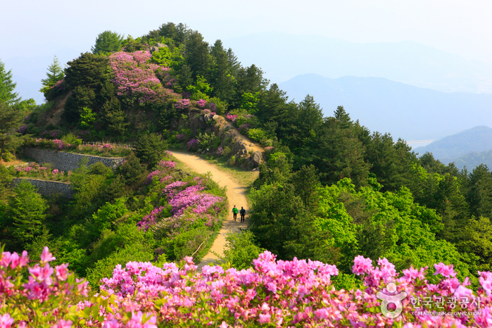
Baraebong Peak (바래봉)
11.1Km 2024-04-07
196, Baraebong-gil, Namwon-si, Jeonbuk-do
+82-63-630-8900
Baraebong Peak gets its name from its resemblance to an upside down barittae (a wooden rice bowl used by temple priests). The mountain is characterized by round slopes and fields of royal azalea flowers in spring. Trekking starts at Yongsan Village, 1.5 kilometers away from Unbong-eup. The trail follows a gentle path through a forest reserve behind a ranch and up to the peak. The last section of the trail before reaching the summit is covered in royal azaleas in full bloom from late April until May. The view from the peak includes the whole vista of Jirisan Mountain.
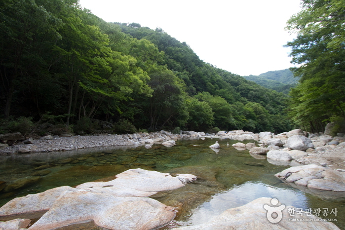
Dalgunggyegok Valley (달궁계곡)
11.1Km 2024-04-07
Jirisan-ro, Sannae-myeon, Namwon-si, Jeonbuk-do
Dalgunggyegok Valley is a valley located within the Jirisan National Park. It spans 6 kilometers from Dalgung Village to Simwon Village. Surrounded by dense primeval forests, it showcases the pristine beauty of an untouched valley where human hands have yet to reach. The combination of the valley and cliffs creates stunning scenery. Nearby Dalgung Village also preserves remnants of ancient Mahan palaces.
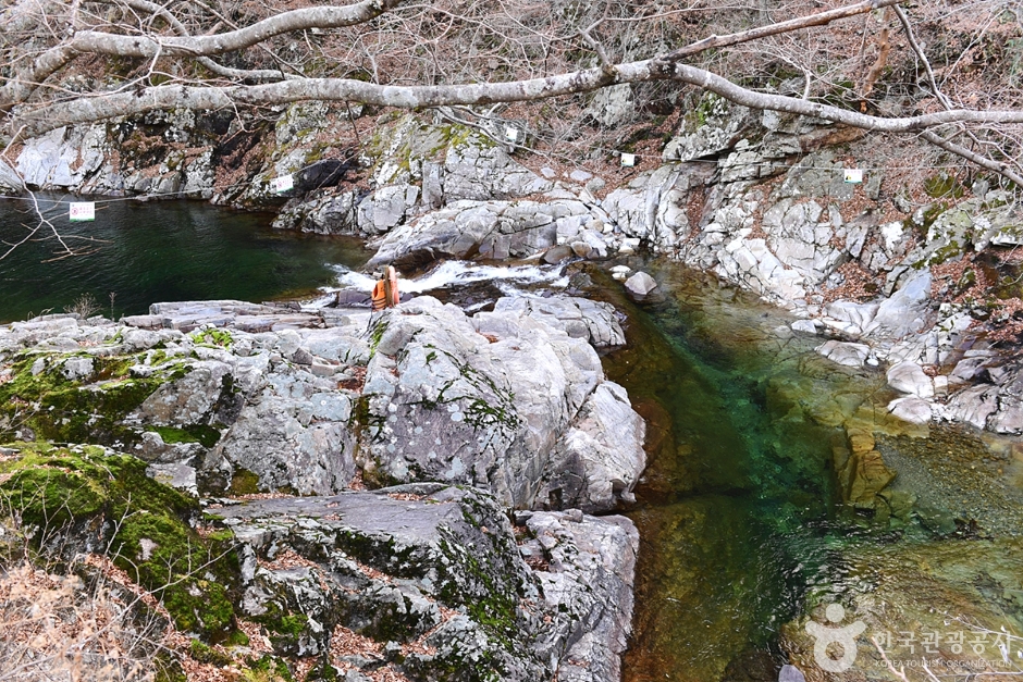
Baemsagolgyegok Valley (뱀사골 계곡)
11.2Km 2024-04-07
Buun-gil, Namwon-si, Jeonbuk-do
+82-63-630-8900
Located in Namwon, Jeollabuk-do, Baemsagolgyegok is a 9-km grand valley, situated at the northern foot of Jirisan Mountain. Stretching from Banyabong Peak and Tokkibong Peak toward Sannae-myeon of Namwon-si, the valley is renowned for its beautiful autumn foliage.
Baemsagolgyegok Valley is popular as a summer vacation destination because there’s always an abundance of water and trees. In the fall, the hills become ablaze with autumn tints, small streams flow over rock beds, and small pools of clear water from under the rocks create a beautiful sight. Other notable places nearby include Seonindae, Seoksil, Yoryongdae, Tagyongso, Byeongso, Byeongpungso, Jeseungdae and Ganjangso.
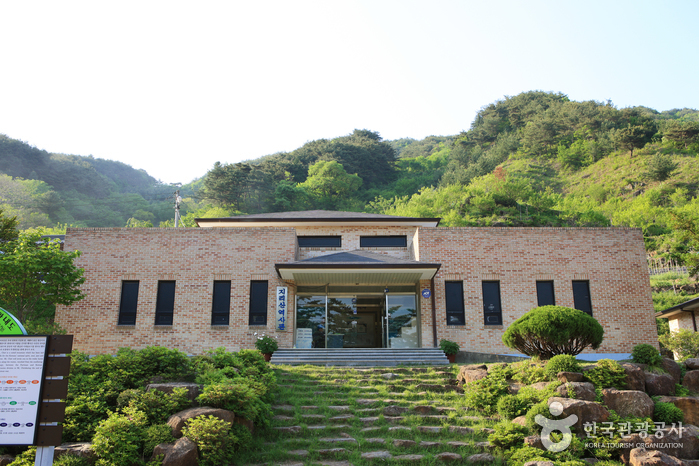
Jirisan History Museum (지리산역사관)
12.4Km 2021-06-15
1438, Hwagae-ro, Hadong-gun, Gyeongsangnam-do
+82-55-880-2954
Jirisan History Museum is located within Jirisan National Park at the start of the hiking course to Byeoksoryeong Pass. Rather a small museum, it provides detailed information about the history of North Korean partisans and the routes that they took throughout the mountain during the Korean War. The museum also exhibits the war relics, lifestyle of the mountain villagers and local produce of Hadong.
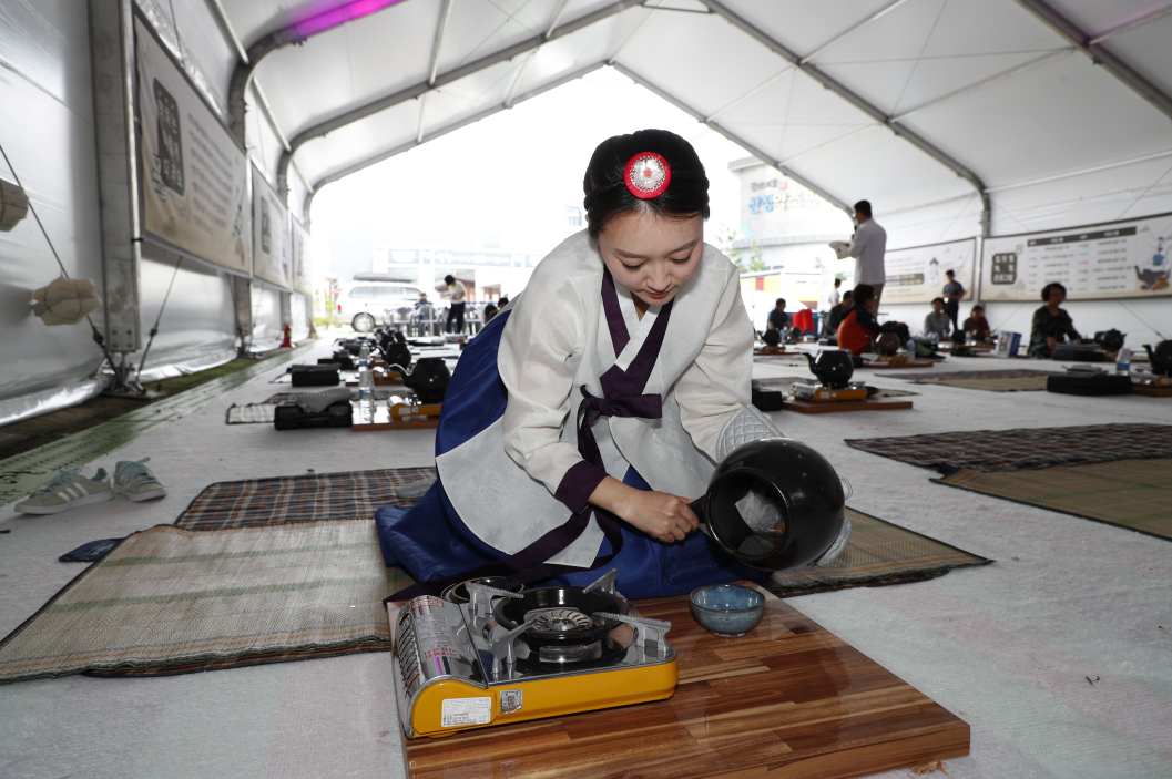
Sancheong Medicinal Herb Festival (산청한방약초축제)
12.7Km 2025-07-11
61 Donguibogam-ro 555beon-gil, Geumseo-myeon, Sancheong-gun, Gyeongsangnam-do
+82-55-970-6670
The Sancheong Herbal Medicinal Festival is a celebration for those interested in traditional herbal medicine. Donguibogam (Principles and Practice of Eastern Medicine) and its author, Heo Jun, are highly regarded in Korean medicine. Sancheong, where Heo Jun studied, is home to Jirisan Mountain, which is often seen as a treasure trove by Korean medicine doctors due to being a habitat of over 1,000 species of medicinal herbs. The festival features Korean medicine clinics offering treatments like acupuncture, while the festival square is transformed into an herbal garden with photo zones, tea drinking spots, spaces for making herbal flower pots, and exhibitions and sales of herbal flower pot goods. Visitors can also participate in making herbal sweet rice puffs, nostalgic herbal dalgona candy, herbal cocktails, and herbal tea brewed in a large decoction pot.
◎ Dongui bogam
Dongui bogam is a medical encyclopedia completed in 1610, written by Heo Jun after a meticulous study and observation of medical books and practices of China and Joseon. It is considered the best medical encyclopedia in the East and was registered as a UNESCO Memory of the World in 2009.
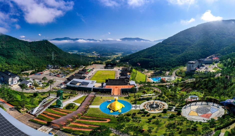
Sancheong Donguibogam Village (산청 동의보감촌)
12.8Km 2025-10-27
45-6, Donguibogam-ro 555beon-gil, Geumseo-myeon, Sancheong-gun, Gyeongsangnam-do
Enjoy various traditional Korean medicine in one place!
Sancheong Donguibogam Village is home to the Museum of Sancheong Korean Medicine, Korea's first traditional Korean medicine-themed museum created in 2007; the Korean Medicine Theme Park; the Sancheong Medicinal Herb Hall; the 'Ki' Experience Hall; the Korean Medicine Recreational Forest and the Korean medical clinics. The village allows you to experience 'healing' moments through traditional medicine. Here, you can learn diverse knowledge about traditional Korean medicine, organized by Heo Jun, the author of Donguibogam (medical encyclopedia). If you are suffering from chronic stress, look no further than Sancheong Donguibogam Village.
Baemsagol Jirisan Sikdang (뱀사골 지리산식당)
14.0Km 2024-04-07
271 Jirisan-ro, Sannae-myeon, Namwon-si, Jeonbuk-do
+82-63-626-8800
Baemsagol Jirisan Sikdang specializes in baeksuk (whole chicken soup) and heukdwaeji gui (grilled black pork). They prepare healthy dishes using wild vegetables and traditional Korean medicinal ingredients collected from Jirisan Mountain. In addition to bibimbap and acorn jelly salad, they also offer dishes like grilled deodeok. Visitors can also enjoy their meals on the outdoor tables set up by Dalgunggyegok Valley.
 English
 한국어
한국어 日本語
日本語 中文(简体)
 Deutsch
 Français
 Español
 Русский