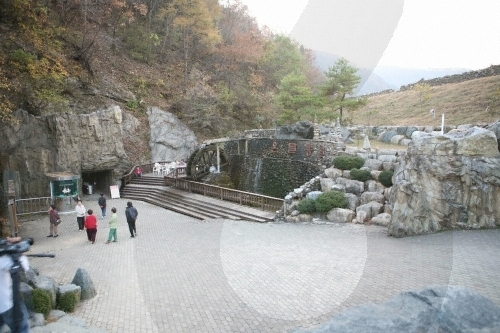
Danyang Ondaldonggul Cave (단양 온달동굴)
15.6Km 2020-01-02
23, Ondal-ro, Yeongchun-myeon, Danyang-gun, Chungcheongbuk-do
+82-43-423-8820
Ondaldonggul Cave is located underground at the foot of Seongsan Mountain, where Ondalsanseong Fortress is situated. It is a natural limestone cave that is estimated to have begun forming around 450 million years ago. The total 760 meter-long cave covers an area of 349,485 square meters. The cave mouth is two meters high, while the cave itself is 5 to 10 meters high and about 5 meters wide. The cave features stairway structure and contains an abundance of beautiful stalagmites and stalactites. The average temperature of the cave maintains 14 degrees Celsius in summer and 16 degrees Celsius in winter, making it a perfect all-year-round attraction. The cave is rich in underground water resources and there is a 0.8 to 1 meter-deep cave river flowing at the bottom of the cave floor. The cave also has over 40 small ponds that are inhabited by a variety of living organisms like fish and insects.
Situated on top of the mountain peak to the left of the cave is Ondalsanseong Fortress. The fortress has been preserved in its original form throughout some 1,400 years and shows the advanced building skills of Goguryeo Era (37 BC-668 AD). The annual Ondal Culture Festival is held every October around Ondaldonggul Cave and Ondalsanseong Fortress in memory of the legendary love story between General Ondal and Princess Pyeonggang. Other attractions in the area include a theme park and Jangseung (Korean traditional totem poles) Park.

Ondal Tourist Area (온달관광지)
16.2Km 2024-02-26
23, Ondal-ro, Yeongchun-myeon, Danyang-gun, Chungcheongbuk-do
Ondal Tourist Area is the site of a battle between Goguryeo and Silla in the 6th Century over the control of the Hangang River. It is home to Ondal Exhibition Hall, the Ondal Open Film Set, Ondalsanseong Fortress, and Ondaldonggul Cave, inspired by the story of Goguryeo general Ondal and Princess Pyeonggang. Many Korean historical shows have been filmed in the Ondal Open Film Set. Ondaldonggul Cave was formed by the dissolution of limestone created during the Paleozoic period.
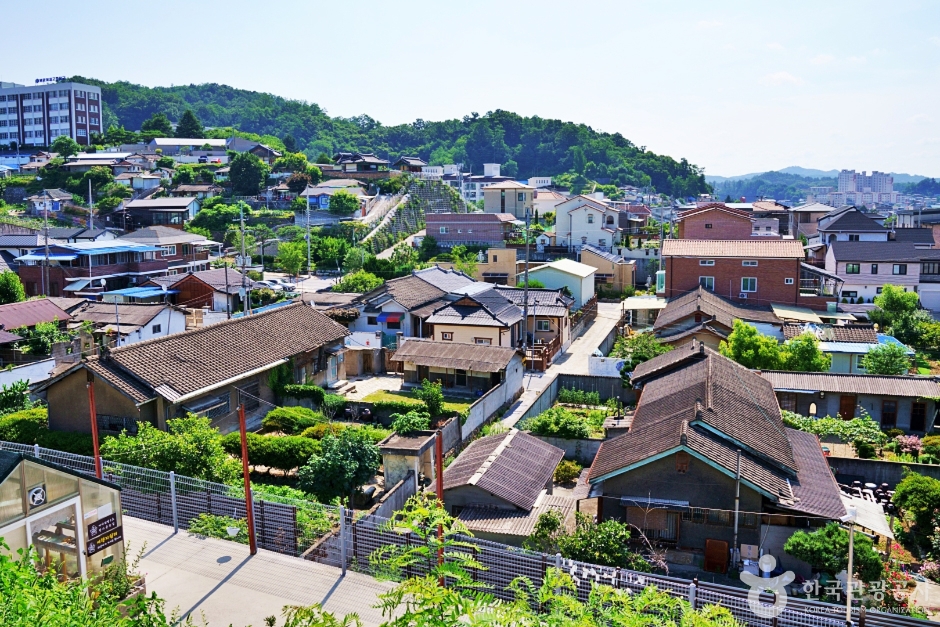
Yeongju Modern History & Culture Street (영주근대역사문화거리)
18.0Km 2024-02-23
Yeongju-dong, Yeongju-si, Gyeongsangbuk-do
Yeongju Modern History and Culture Street serves as a historical and cultural hub, encapsulating the life and times of early twentieth-century Yeongju. The street is dotted with cultural properties officially recognized by the Cultural Heritage Administration. Highlights include the preserved official residences No. 5 and No. 7 of Yeongju Station, once home to railway station employees. Additionally, visitors can explore the Pungguk Rice Mill, showcasing vintage rice milling machinery; Yeongju Jeil Church, a 1909-built structure exemplifying Gothic-style architecture; Yeongju-dong Modern Hanok, a subsidiary structure of an ancient residence; and the still-operating Yeonggwang Barber Shop, a testament to the area's enduring heritage.
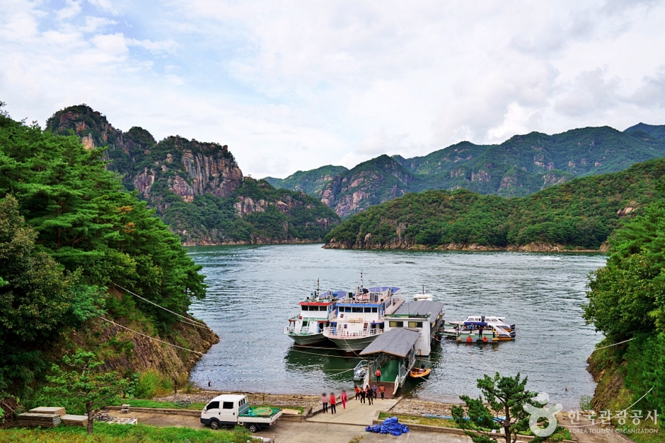
Janghoe Quay (장회나루)
18.1Km 2024-02-27
3811-19 Worak-ro, Danseong-myeon, Danyang-gun, Chungcheongbuk-do
Janghoe Quay is a pavilion where visitors can enjoy the breathtaking scenery of Gudambong Peak and Chungjuho Lake in Danyang. The towering mountains, cliffs, and the shimmering waves of Chungjuho Lake create a beautiful landscape. With the presence of the Chungjuho Excursion Boat Terminal, it is a popular destination for domestic and international travelers, offering the opportunity to take a cruise around Danyang.
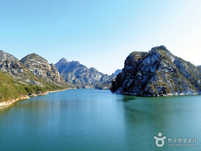
Gudambong Peak & Oksunbong Peak (구담봉 & 옥순봉)
18.7Km 2020-06-11
Janghoe-ri, Danseong-myeon, Danyang-gun, Chungcheongbuk-do
+82-43-422-1146
Gudambong Peak and Oksunbong Peak (alt. 372m) are widely known as two of the “Eight Scenic Views of Danyang." Gudambong Peak (lit. Turtle Pond Peak) gets its name from the reflection of its rugged cliffs on the lake below, which is said to look like a turtle. Oksunbong Peak (lit. Bamboo Shoot Peak), well known for its magnificent scenery, was so named because its white and mossy rocks stand high like fresh bamboo shoots.
The historic book Yeojiseungnam (Geographical Survey of Korea) describes how Kim Il-son, a civil officer in the Joseon Dynasty, greatly extolled the beauty of its marvelous ravines. Both Gudambong Peak and Oksunbong Peak offer spectacular views of Chungjuho Lake and Geumsusan Mountain.
Olive Young - Gyeongbuk Yeongju Station Branch [Tax Refund Shop] (올리브영 경북영주역점)
19.0Km 2024-06-27
35, Daehak-ro, Yeongju-si, Gyeongsangbuk-do
-
Homeplus - Yeongju Branch [Tax Refund Shop] (홈플러스 영주)
19.1Km 2024-04-18
29, Daehak-ro, Yeongju-si, Gyeongsangbuk-do
-
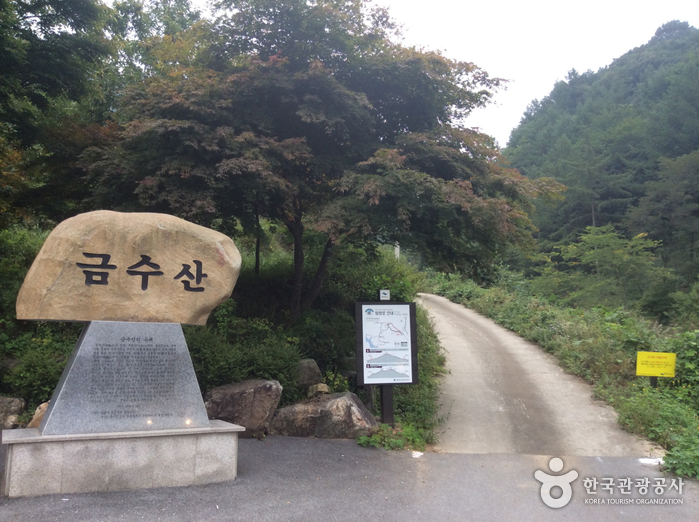
Geumsusan Mountain (금수산)
19.2Km 2021-05-28
210, Sanghak 1-gil, Danyang-gun, Chungcheongbuk-do
+82-43-653-3251
Geumsusan Mountain, originally called Baegamsan Mountain, was renamed by noted Joseon-period scholar Yi Hwang (pen name Toegye) when he was the chief governor of Danyang County, saying its graceful features matched the fineness of silk embroidery. The mountain is beautiful throughout the year with bright foliage in fall and an ice cave that stays frozen until early April. The view from the summit of the mountain resembles a pregnant woman lying on her side, and there is a legend that women who pray for a son here will have their wish come true.
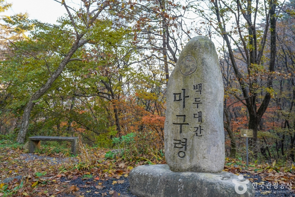
Maguryeong Pass / Gochiryeong Pass (마구령/고치령)
19.7Km 2024-02-23
[Maguryeong Pass] Imgok-ri, Buseok-myeon, Yeongju-si, Gyeongsangbuk-do
Maguryeong Pass and Gochiryeong Pass stand as iconic hills of Sobaeksan Mountain. They are known for their historical significance as rugged pathways where people and goods traversed during the Goryeo and Joseon dynasties. Situated on the easternmost edge of Sobaeksan Mountain, Maguryeong Pass derives its name from its function: "Magu" meaning "harness" and "Ryeong" meaning "pass" in Korean, highlighting its past as a route where merchants commonly traveled on horseback. Meanwhile, Gochiryeong Pass served as a vital transport link to the Gwandong and Hoseo regions. In the Silla dynasty, this pass was earmarked for palace construction at the base of the hill, which led to its name "Gochiryeong" – "Go" indicating "old", "Chi" representing "hill", and "Ryeong" meaning "pass" in Korean – effectively translating to "old hill pass".
 English
 한국어
한국어 日本語
日本語 中文(简体)
 Deutsch
 Français
 Español
 Русский