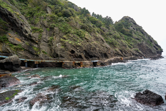
Haengnam Coastal Walking Path (행남 해안산책로)
2.7 Km 13961 2021-07-28
Dodong-ri, Ulleung-gun, Gyeongsangbuk-do
+82-54-790-6394
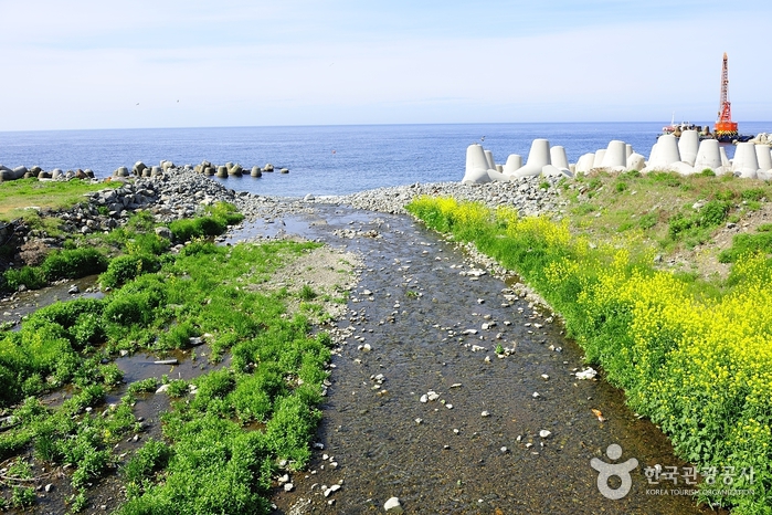
Haengnam Coastal Walking Path starts from Dodonghang Port and ends at Haengnam Village. The trail provides the perfect opportunity to see the coastal beauty of the island, with bridges passing open waters between natural cave formations and erroded valleys. About 400 meters from the village is Haengnam Lighthouse. The lighthouse area shows Jeodonghang Port through the pine trees, and the hillside is covered in beautiful yellow flowers in autumn.
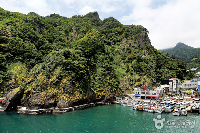
Dodonghang Port (도동항)
2.8 Km 11319 2021-06-08
Dodong 1-gil, Ulleung-gun, Gyeongsangbuk-do
+82-54-790-6454
Dodonghang Port is a ferry port of Ulleungdo Island, located 188 kilometers northeast of Pohang. The port has a 80-meter quay wall which was completed in 1977 with plans to develop the island into a tourist attraction. The port's yearly capacity is 20,000 tons of cargo, mostly consisting of imported goods for the island residents and export of squid caught around Ulleungdo Island. As ferry passengers on board approach the port, they will see Manghyangbong Peak to the left and Haengnam Lighthouse to the right.
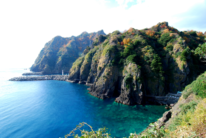
Dodong Coastal Trail (도동 해안산책로)
2.9 Km 0 2024-03-29
Dodong-ri, Ulleung-eup, Ulleung-gun, Gyeongsangbuk-do
Dodong Coastal Trail leads to Jeodong Coastal Trail, and together, they form Haengnam Coastal Trail. Dodong Coastal Trail corresponds to section 1 of Ulleung Haedam-gil (2.8km) and is also known as the Coastal Trail 34 course. There is a walking trail with a rainbow bridge and LED streetlights with the geopark logo, making it an attractive geological site among tourists.
Various geologic structures formed by early volcanic activity on Ulleungdo Island can be observed on the Dodong Coastal Trail. There is a gradual decrease in the age of rock formations as you go from Dodong Port to Dodong Lighthouse. Basaltic lava flows, Clastic sedimentary rocks (rocks made up of pieces transported by landslides), ignimbrite (a volcanic rock formed by the consolidation of material deposited by pyroclastic flows), and trachyte (an extrusive igneous rock) can be found from bottom to top.
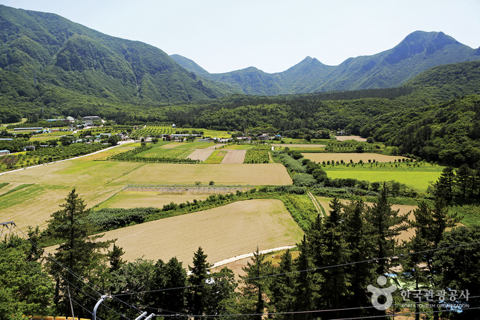
Nari Basin (나리분지)
2.9 Km 13184 2021-05-13
Nari-gil, Ulleung-gun, Gyeongsangbuk-do
+82-54-790-6423
Originally a caldera formed on the northern Seonginbong Peak, Nari Basin is the only flatland on Ulleungdo Island. The lava flow from the volcanic eruption created two other craters, which were turned into Nari Village in the northeast and Albong Village, now uninhabited, in the northwest. Records were found that the island was inhabited since the Usan-guk period, but the islanders had to move out of the island in the earlier Joseon period until a new settlement policy was enforced later on.
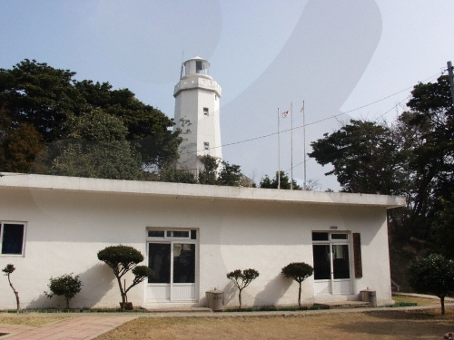
Dodong Lighthouse (도동등대(행남등대))
3.1 Km 10147 2021-06-23
291-71, Haengnam-gil, Ulleung-gun, Gyeongsangbuk-do
+82-54-791-2594
Dodonghang Lighthouse is located on the easternmost point of Ulleungdo Island, between Dodonghang and Jeodonghang Ports. The lighthouse is also called Haengnam Lighthouse after the nearby village. On clear days, visitors can see Dokdo Island to the east from atop the lighthouse. To the north, visitors can see the beautiful landscape of Jeodonghang Port, Chotdaebawi Rock, and Seonginbong Peak.
The lighthouse opened as an unmanned lighthouse in December of 1954. However, an increase in fishing boats operating in the area led to the upgrade into a manned lighthouse in June 1979.
Tonggumi Pebble Beach (통구미몽돌해변)
4.3 Km 14433 2021-10-25
Ulleungsunhwan-ro, Ulleung-gun, Gyeongsangbuk-do
+82-54-790-6454
At Tonggumi Pebble Beach on Ulleungdo Island, you can enjoy the views of impressive sea-side cliffs, the glittering ocean, and the dark pebbles that dot the landscape, all at once. There are always waves at this 1-kilometer-long beach with waters ranging in depth from 1 to 3 meters. It is easy to find the beach, as it is located along the Ulleungdo Coastal Drive. Various facilities such as bathrooms, parking lots, homestays, restaurants, drugstores, supermarkets and accommodations are found near the beach.

Healing Stay Kosmos [Korea Quality] / 힐링 스테이 코스모스 리조트 [한국관광 품질인증]
4.5 Km 816 2024-05-13
88-13, Chusan-gil, Ulleung-gun, Gyeongsangbuk-do
Healing Stay Kosmos is located at the edge of a cliff next to Songgotsan Mountain in Ulleungdo Island. The exterior is in a spiral shape, reflecting the trajectories of the sun and moon. The six-vault structure, which extends outward in a spiral shape from the center of the building, is the most essential element—each of the vaults form an independent space inside. Due to the spiral shapes, the entrance to the vaults temporarily blocks the landscape outside; however, as the guest enters further into the vault, the view to the surrounding landscape gradually opens up, and each vault reveals a unique view. This allows every guest to naturally immerse themselves into the hotel’s beautiful architecture and the surrounding landscape. The hotel also observes strict hygiene and disinfection to ensure the safety and convenience of guests. The maintains the cleanliness of every room and bedding every day. To prevent the spread of COVID-19, the hotel staff regularly ventilate and disinfect all facilities and a designated disinfection and quarantine manager strictly monitors the staff’s compliance with the social distancing manual. The hotel also provides a complimentary healing kit, which includes a hand sanitizer (as well as a trekking map and specialty snacks from Ulleongdo Island), to all guests.
![Elephant Rock [Ulleungdo-Dokdo National Geopark] (코끼리바위 (울릉도, 독도 국가지질공원))](http://tong.visitkorea.or.kr/cms/resource/79/2499379_image2_1.jpg)
Elephant Rock [Ulleungdo-Dokdo National Geopark] (코끼리바위 (울릉도, 독도 국가지질공원))
4.6 Km 11214 2024-02-23
Hyeonpo-ri, Buk-myeon, Ulleung-gun, Gyeongsangbuk-do
+82-54-790-6182
Elephant Rock is situated approximately 500 meters off the northern coast of Ulleungdo Island and rises to a x_height of 50 meters. It derives its name from its remarkable resemblance to an elephant. This distinctive formation resulted from lava solidifying after a volcanic eruption, with the unique gap between what appears to be the elephant's trunk and its body sculpted over time by the relentless action of the waves.
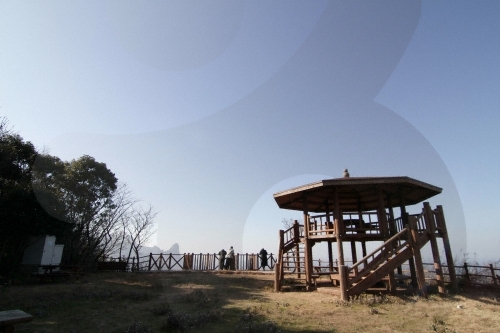
Seokpo Observatory (석포전망대)
4.8 Km 6107 2020-03-24
Cheonbu-ri, Ulleung-gun, Gyeongsangbuk-do
+82-54-790-6392
Seokpo Observatory is located in Seokpo village, a small fishing town at the northernmost point of Buk-myeon on Ulleungdo Island.
Ulleungdo Island has three popular scenic lookouts, one of which is Seokpo Observatory to the north. Created in 1905, the observatory was used by the Japanese through 1945 to monitor movements of Russian warships.
Seokpo Observatory offers views of the East Sea between Ulleungdo and the Korean Peninsula. The observatory has an 8-sided pavilion with lookout deck and telescope from which views of picturesque Jukdo and the majestic coastline of Buk-myeon are available. The area is also nearby the 3 popular attractions of Gongam (an elephant-shaped rock), Gwaneumdo, and Samseonam. Below the observatory is Seokpo Resting Area and a trekking course connecting Seokpo Observatory and Naesujeon Sunrise Observatory.
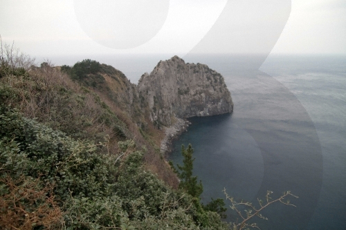
Turtle Rock & Natural Wild Juniper Habitat (거북바위 및 향나무 자생지 (울릉도, 독도 국가지질공원))
4.8 Km 21205 2021-06-29
Taeha-ri, Ulleung-gun, Gyeongsangbuk-do
+82-33-791-2113
Turtle Rock was given its name for its rock formation that resembles the shape of turtles climbing out to the rock. The Turtle Rock is a volcanic rock that formed from the molten lava from Ulleungdo Island's early volcanic activity. Solidified lava flow as well as chilled margins can still be seen along the rock's slope. The western cliff of the rock is Tonggumi Village, where it serves as a home to wild juniper trees. On the northwestern side of the rock is Daepunggam Village, also a natural habitat for wild juniper trees. Both sites were designated as Natural Monuments for their significance. The juniper trees here are known to have a slower growth rate than those under normal condition due to rough winds.
 English
 한국어
한국어 日本語
日本語 中文(简体)
 Deutsch
 Français
 Español
 Русский