
Healing Stay Kosmos [Korea Quality] / 힐링 스테이 코스모스 리조트 [한국관광 품질인증]
7.0 Km 816 2022-01-01
88-13, Chusan-gil, Ulleung-gun, Gyeongsangbuk-do
Healing Stay Kosmos is located at the edge of a cliff next to Songgotsan Mountain in Ulleungdo Island. The exterior is in a spiral shape, reflecting the trajectories of the sun and moon. The six-vault structure, which extends outward in a spiral shape from the center of the building, is the most essential element—each of the vaults form an independent space inside. Due to the spiral shapes, the entrance to the vaults temporarily blocks the landscape outside; however, as the guest enters further into the vault, the view to the surrounding landscape gradually opens up, and each vault reveals a unique view. This allows every guest to naturally immerse themselves into the hotel’s beautiful architecture and the surrounding landscape. The hotel also observes strict hygiene and disinfection to ensure the safety and convenience of guests. The maintains the cleanliness of every room and bedding every day. To prevent the spread of COVID-19, the hotel staff regularly ventilate and disinfect all facilities and a designated disinfection and quarantine manager strictly monitors the staff’s compliance with the social distancing manual. The hotel also provides a complimentary healing kit, which includes a hand sanitizer (as well as a trekking map and specialty snacks from Ulleongdo Island), to all guests.
![Seonginbong Primeval Forest [National Geopark] (성인봉 원시림 (울릉도, 독도 국가지질공원))](http://tong.visitkorea.or.kr/cms/resource/57/2370057_image2_1.jpg)
Seonginbong Primeval Forest [National Geopark] (성인봉 원시림 (울릉도, 독도 국가지질공원))
8.1 Km 10938 2021-04-23
Namyang-ri, Ulleung-gun, Gyeongsangbuk-do
+82-54-790-6182
The foot of Seonginbong Peak is covered with thick primeval forests designated as Natural Monument No. 189. This forest is Ulleungdo Island's only flat area with a diameter of approximately 2 kilometers. It is a caldera formed by volcanic activities and developed over time. The area has many rare plants only found in Ulleungdo Island.
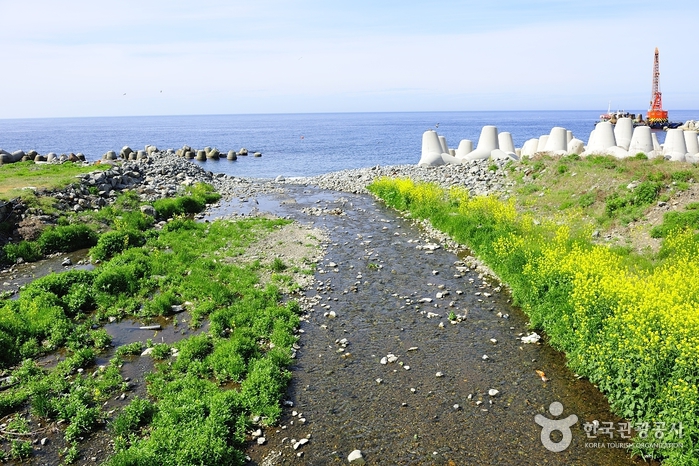
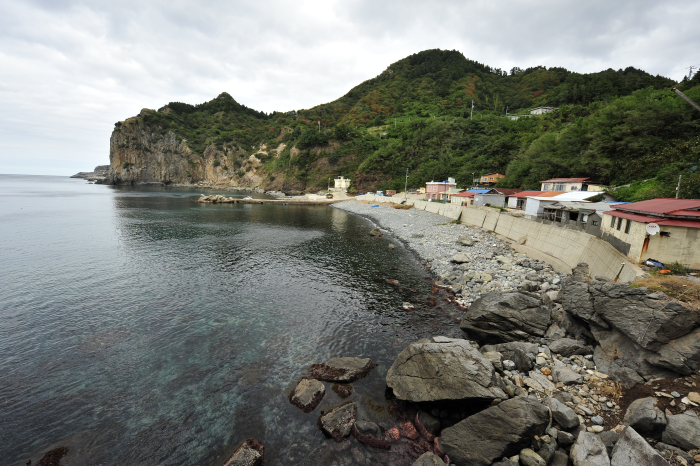
Tonggumi Pebble Beach (통구미몽돌해변)
9.8 Km 14433 2021-10-25
Ulleungsunhwan-ro, Ulleung-gun, Gyeongsangbuk-do
+82-54-790-6454
At Tonggumi Pebble Beach on Ulleungdo Island, you can enjoy the views of impressive sea-side cliffs, the glittering ocean, and the dark pebbles that dot the landscape, all at once. There are always waves at this 1-kilometer-long beach with waters ranging in depth from 1 to 3 meters. It is easy to find the beach, as it is located along the Ulleungdo Coastal Drive. Various facilities such as bathrooms, parking lots, homestays, restaurants, drugstores, supermarkets and accommodations are found near the beach.
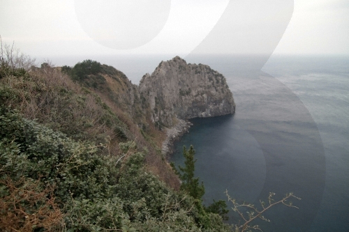
Turtle Rock & Natural Wild Juniper Habitat (거북바위 및 향나무 자생지 (울릉도, 독도 국가지질공원))
10.2 Km 21205 2021-06-29
Taeha-ri, Ulleung-gun, Gyeongsangbuk-do
+82-33-791-2113
Turtle Rock was given its name for its rock formation that resembles the shape of turtles climbing out to the rock. The Turtle Rock is a volcanic rock that formed from the molten lava from Ulleungdo Island's early volcanic activity. Solidified lava flow as well as chilled margins can still be seen along the rock's slope. The western cliff of the rock is Tonggumi Village, where it serves as a home to wild juniper trees. On the northwestern side of the rock is Daepunggam Village, also a natural habitat for wild juniper trees. Both sites were designated as Natural Monuments for their significance. The juniper trees here are known to have a slower growth rate than those under normal condition due to rough winds.
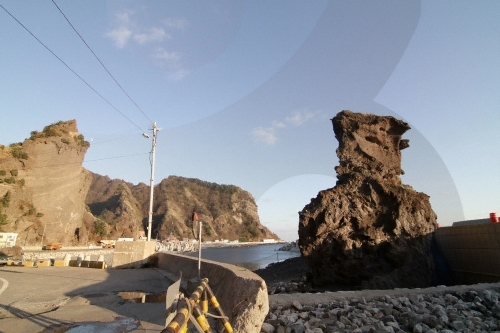
Sajabawi Rock (사자바위)
11.5 Km 9070 2020-06-30
Namseo-ri, Ulleung-gun, Gyeongsangbuk-do
+82-54-790-6454
The western coast of Ulleungdo Island is perfect for taking in the sunset; Sajabawi Rock in Namyang-ri is easily one of the most accessible places, located right next to the coastal road. The scenery is complete with squid drying in the the last rays of the sun at the coastal village, and boats heading heading out to catch more squid when the sun finally sets.
Taeha Coastal Trail and Daepunggam Cliff (태하 해안산책로 및 대풍감 (울릉도, 독도 국가지질공원))
11.8 Km 0 2024-03-29
Taeha-ri, Seo-myeon, Ulleung-gun, Gyeongsangbuk-do
Taeha Coastal Trail can be reached by crossing the pedastrian bridge next to Hwangtogul Cave. While crossing the bridge, visitors can enjoy murals of Taeha Village and a photo zone. Taeha Coastal Trail is made up of trachyte and agglomerate rocks, and boasts beautiful coastal scenery due to the unique topography eroded by the wind. It is also where one can observe tafoni, a honeycomb-shaped rocks that weathered by the reaction of salts contained in sea breezes.
By taking the Taeha Hyangmok Tour Monorail for about 6 minutes and walking along the trail for about 20 minutes, visitors will reach Ulleungdo Lighthouse (Taeha Lighthouse) and the Hyangmok Geo Skywalk.
Junipers in Daepunggam Cliff grew in weathered soil formed in the cracks of columnar joints, creating a unique ecological environment isolated from inland areas for a very long time. Due to its significance, Junipers were designated as natural monuments.
Hakpo Coast (학포해안 (울릉도, 독도 국가지질공원))
12.0 Km 0 2024-03-29
166-29 Hakpo-gil, Seo-myeon, Ulleung-gun, Gyeongsangbuk-do
Hakpo is known for its beautiful coast as well as the remains that record the frontier history of Ulleungdo Island. There are agglomerate, tuff, and trachyte layers along the Hakpo Coast. The relatively hard trachyte layer that cannot be eroded by waves and remains has formed a cape (a large piece of land sticking out into the sea), while the agglomerate and tuff layers, which are subject to weathering and erosion, have formed a bay. Additionally, sea cliffs are found along the coast. As the lower part of the vertical columnar joints erodes, the upper part of the cliff collapses due to gravity, creating a steep cliff as the process is repeated. Visitors can also enjoy the atmosphere of Hakpo at the nearby Hakpo Campground.
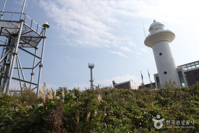
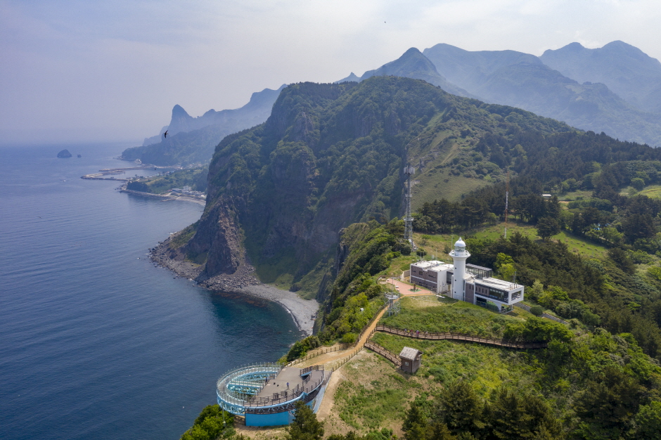
Ulleungdo Lighthouse (울릉도 등대 (태하등대))
12.7 Km 18822 2022-09-08
188, Taehadeungdae-gil, Ulleung-gun, Gyeongsangbuk-do
+82-54-791-5334
Ulleungdo Lighthouse, sometimes called Taeha Lighthouse, was first lit in 1958 as a guiding light for boats coming to and from Ulleungdo Island. The lighthouse is a round, white concrete structure rising 7.6 meters high. With a new prisim light placed in 2003, the lighthouse can reach as far as 50 kilometers away. The hiking trail up to the lighthouse is a natural, narrow path among groves of trees. The gentle slope is surrounded by uniquely shaped cliffs, so it is a popular hiking course for tourists.
 English
 한국어
한국어 日本語
日本語 中文(简体)
 Deutsch
 Français
 Español
 Русский